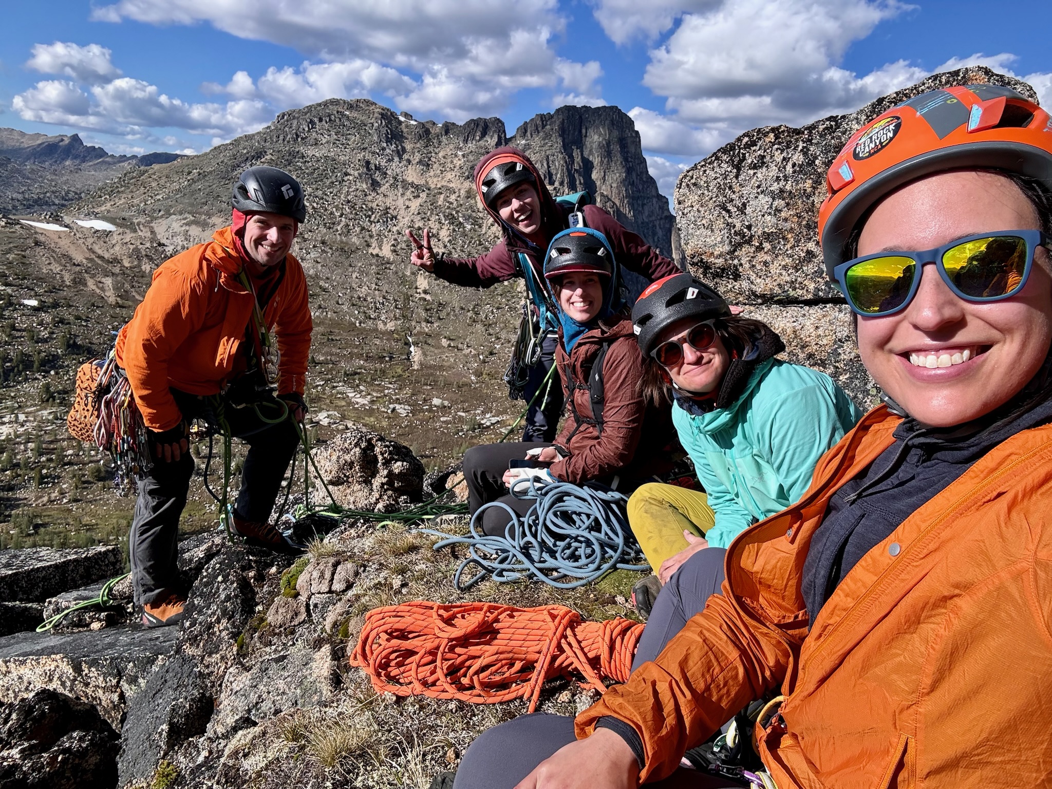
Ride the Lightning

If you’re just reading this for the fun bit of the story (or if you want to avoid hearing too much beta about the route) skip ahead to “Going down.”

May 3, 2014

A plan falls into place.
A Mountaineers Crag field trip was happening in Tieton. Jarred was signed up as a student for Sunday, and suggested that I join him during his free Saturday to do some other climbing just for fun. He & I would drive out together, and I’d drive back alone Saturday night while he got a ride with Ben & Andrea at the end of Sunday. But what exactly should we climb out there? Having never been to Tieton before, and lacking the guidebook for the area, I turned to mountainproject.com. There’s a pie-chart of types of climbing with a sliver of color that supercharged my curiosity and desire. 131 rock routes, and 1 alpine route. What exactly do they mean by an alpine route in an area that’s mostly single-pitch cragging?? I had to find out. The answer is Ride the Lightning, a 7-pitch route with a mix of bolts and trad placements, 5.9 at the hardest, with most pitches being 5.8. There’s no way I could resist. There’s a fantastic route description & topo by the first ascensionist here: http://www.cascadeimages.com/cr/tieton/rtl/rtl.htm. It’s on Goose Egg Mountain, which is a mountain in the sense that Tiger Mountain is a mountain, not like Mt Stuart or anything. I’d probably have to lead every pitch since Jarred is not quiet yet leading trad, but I was okay with that. I believe there’s other big multipitch routes in Tieton, but RTL is all mountainproject.com lists at the moment.

I knew this route would be pushing my abilities a bit. After more than a year of being comfortable leading at-most 5.7 routes on trad gear, I had just begun to believe in myself as a 5.8 trad leader within the last month, after ticking off both Party In Your Pants and Crossing The Threshold back at Vantage, amongst some shorter routes. A couple of factors gave me confidence though: (1) The first ascent was in 2001, so that 5.9 rating is probably on a more sane scale than some 1950’s Fred Beckey first ascent. (2) Jarred had just bought twin-ropes, making full 60m rappels a possibility, and all the belays promised to be bolted, so in theory it would be easy give up and go back the way we came at any point if it proved too challenging. In fact, I’d rather intentionally climb only the first 6 pitches and rappel them rather than deal with the loose 7th pitch and the fourth class gully downclimb described by the guide. I really hate fourth class. (3) The 5.9 pitch wasn’t until the 5th pitch, so even if it was unclimbable for me, we could still feel like we made a solid accomplishment by climbing four challenging pitches.

Gearing up.

  • Two 60m Petzl Salsa 8.2mm ropes, orange & brown, used as twin-ropes.
  • 6 sport quickdraws
  • 10 alpine draws
  • 3 double runners
  • Black Diamond C4s #0.3 through #4, with doubles of #1, #2, & #3
  • set of stoppers
  • Crack gloves. (Singing Rock rubber ones for me, tape gloves for Jarred. Our hands would have been very bloody without these.)
  • Helmets. (As always, but especially here because occasionally a hold would flake off and fly away.)
  • Walkie-talkies, which were unnecessary because we were always in shouting distance on the way up, but they crapped out during the long rappels where they actually would have helped.
  • small backpack carried by Jarred with each of our sandwiches & water (REI Flash 18 pack)
  • a light rain shell (Jarred) and a light wind-breaker (me), which was meant as an emergency layer, but we ended up wearing them all day since you climb into an area of higher winds, making it chillier than it was on the ground

I know that’s a lot of draws, but we used every last one of them, I wouldn’t bring any less. I probably could have done without the stoppers, I only placed a single one all day (BD stopper #10, the silver one, for the first piece on pitch 3, where there’s no risk of zippering.) For the cams, I probably didn’t need anything smaller than the #0.75 after all, unless I wanted to use a #0.4 cam instead of the #10 stopper on pitch 3. Doubles of the #1, #2, & #3 were a good call. It’s not really necessary, but a third #1 cam (red) would have allowed me to overprotect the dihedral in pitch 2. The big silver #4 was only placed once (in the off-width in pitch 5,) and it was totally worth carrying it the whole day.

The twin-rope setup was new to both of us, but it was straight forward and worked out well. We both brought a Reverso 4, which gripped the skinny rope just enough with it’s breaking grooves, but since it was just-enough, we were keen to always use belay gloves, and maintain good autoblock habits when rappelling. Those ropes are also rated as half-ropes, but I didn’t want to add the complication of moving separate strands through the belay device at different rates. I intentionally brought the Reverso instead of my beloved Mammut Smart Alpine, because the Smart says it’s only meant for ropes 8.9mm and wider. Someday I’ll buy the other Smart model that’s specced for skinnier ropes so I have both options.

The Approach.
I picked up Jarred at his apartment in Seattle at 4am. We didn’t rush much, we made a stop for gas & gas-station food, another bathroom stop, and a stop very near Tieton to say “Hi” when we spotted Ben & Andrea’s car at a campsite off Hwy 12. They were helping teach at the Mountaineers Crag field trip both Saturday & Sunday, and were getting ready to head to the Royal Columns.  I ran into my friend Doug there too.  After hanging out for a bit, Jarred & I continued on our way and eventually parked at the pull-off clearly described here http://www.cascadeimages.com/cr/tieton/rtl/rtl.htm at 8am. We put on harnesses, gear, and sunscreen at the car, and did the 15 minute approach hike in tennis shoes while carrying our ropes & rock shoes. The weather called for temps just below 70°, sunny, and a 10% chance of rain. Given the south-facing aspect of our route and the fact that we were in Eastern Washington, I had expected to get completely baked, so I had worked during the entire drive to drink a whopping 3.5 liters of water by this point so I’d be okay carrying a single liter of water on the actual climb. (That day I peed from a semi-hanging belay, and later while on lead from a ledge above my last clip, both for the first time in my life. Don’t worry, I kept it off the route!) By 9am we were finally tied in, checked out, and ready for me to get off the ground.

Going up.
I started up the first pitch at 9am. Even though it’s reachable by some easy 3rd class terrain then one friction move, I didn’t like how high off the deck that first bolt was. I think the first ascensionists did a stellar job putting together an amazing route in Ride the Lightning, and I understand the desire to not over-protect the hell out of things with too many bolts, but I do think a bolt before that first friction move would be a responsible safety addition given that the leader has 30 or 40 feet of 3rd class terrain to tumble down if they don’t get that first move right. Anyway, the rest of the pitch is fun, with small but plentiful crimps for hands and tiny-but-good nubs for rock shoes to stick to. It’s stuff that you can keep moving up slowly but surely, and I’d say the 5.8+ rating is about right. Since that first pitch is entirely bolted, I made Jarred carry all the heavier cams so that I’d get to warm up my lead-head without the full rack weight on my harness. It’s a solid full rope length too, with the chains not quite 60 meters above the ground. It’s a lot windier up here on the wall than it was down amongst the trees, so even though it felt like a jacket-free day before climbing, I needed to put my windbreaker on to keep from shivering while belaying, and I kept it on the rest of the day.

The 2nd pitch starts out very much like more of the first pitch, climbing the face and feeling pretty good about it. Eventually it gets over to that big dihedral that’s the hallmark of the route, and the climbing there is really interesting! The crack eats up red & yellow cams and provides a number of awesome hand jams while you stem between the two faces. I reached the roof, and traversed under the roof by continuing to get solid hand-jams in the crack at the back of the roof. There’s a pair of chains below the left edge of the roof, thus ending the 2nd pitch.

The 3rd pitch goes up the corner around left of the roof, then turns right out-of-sight onto the first comfortable-to-stand-on ledge in a while. It turns out this is the end of the pitch, it’s surprisingly short compared to the first two we just did. I couldn’t figure out the mixed-pro anchor that the guide described, but the rap-chains that are there worked really well as a belay anchor. After Jarred was up on the ledge too, we extended the lengths of our rope tie-ins to the anchor so we could sit around on the ledge and take a lunch break without disconnecting from the rope. By this time it was around 12:45pm, which indicated we had been moving a bit slowly, but that was expected since the pitches were long and the climbing moves so close to our skill limits.

The 4th pitch starts out really easy, up a few bolts on small face holds that you’re very used to by now on this route. After the last bolt you have to make a step around an edge and into another corner. I found that step to be quite challenging on lead, even though a fall there probably wouldn’t have been that bad. I somehow managed to pull through it, with some colorful vocals. After that step the next belay anchor is easily reached. This is the first belay anchor we’ve reached that had just bolts, no chains. Some crispy bleached-white webbing indicated someone had rapped from here in the past, as we planned to do, but not before trying the 5th pitch!

The 5th pitch is described as having a scary runout to the first bolt. Once I got to actually see the terrain from the 4th pitch belay anchor, I thought it didn’t look that bad, and I wanted to give it a try. Here’s another place where I think one more bolt would be a responsible addition to the climb. An added bolt 10 feet above the belay anchor would at least prevent a fall from being factor-2. Since there were three bolts at the belay, I clipped one of them as my first piece, and gained some modicum of comfort knowing I was now looking at a factor-1.9 fall. With careful balance, I was able to get that distant bolt without falling, and had no shame about pulling on the draw while I clipped the rope. One more bolt, and then I was faced with a tiny overhang (the crux that makes the darn thing a 5.9) followed by an off-width crack. I tried and backed off a bunch of times. I finally reached up and plugged in a #2 yellow cam, grabbed the cam sling, and French-freed my way up over that overhang. I guess I’m still not a 5.9 trad leader 🙂 After that, I found myself with my left side wedged into the off-width crack. I badly wanted to get more pro in it, but I had hung all of medium to large cams from my left gear loop. I wiggled like a worm in that crack for a while, barely balancing & hanging on, and somehow managed to retrieve a necessary cam from my left side. After that, I made good progress up the off-width. Yellows, blues, and one silver cam where handy up this section, and then you start getting some bolts to follow again. It’s a long pitch, but it continues in a straight line, and eventually you get a pair of bolts (again no chains) to your left as a belay anchor.

After bringing Jarred up to the top of this 5th pitch, it was 2:45pm. I felt great about everything we had accomplished, and figured it was about time to turn around to make sure we could rappel the entire 610 feet of vertical we had just gained before getting close to the dinner hour. The 6th pitch didn’t sound that interesting compared to everything else we’d climbed so far, and I had never intended the climb the 7th pitch anyway since it was described as an awful & dangerous hanging pile of loose boulders. Here at the top of pitch 5 was a great place to call it day and turn around.

Going down.
There’s a diagram of the route on this page, it might help you follow what happens next: http://www.cascadeimages.com/cr/tieton/rtl/rtl.htm

At the chainless 5th pitch belay bolts, Jarred provided a rappel ring, and I provided 10ft of 7mm cord, and with a few fancy knots we had perfectly SERENE rap anchor hanging from those two bolts. We threaded through a rope end, then tied the ropes together with my preferred flemish-bend with double-fisherman’s backup knots. It’s a mighty burly way to connect two ropes, which I feel better about than the alternative Euro-Death-Knot, even one with over a foot of tails. I’d be especially uneasy about the EDK in these brand new super-slippery and skinny ropes. We stacked the rope for a saddle-bag rappel, but that proved to be a waste of time since the slippery rope was quick to fall out of my saddlebags. I rapped first, making sure to traverse climber’s-right so I’d hit the belay bolts at the top of the 4th pitch. Along this rappel, on two occasions I clipped an alpine draw to a bolt so the ropes would continue to be held in the direction I had been angling so far. That would prevent me from penduluming too far left if I slipped, and I would tie the bottoms of the rope to the next anchor so Jarred could retrieve those draws without having major pendulum concerns himself. Just before reaching the 4th pitch belay bolts, I passed the middle-markers on the twin ropes. Knowing that the 4th pitch was only 50 feet, I was sure I could skip it and make it to the chains at the top of pitch #3. I did so, got off the rappel, and though it was nearly impossible to yell back and forth with Jarred at that point, managed to explain the situation and tell him he could safely rappel now. (The radios had crapped out, even though their batteries weren’t dead, and we had successfully tested them earlier in the day. Weird.) Jarred paused his rappel by the 4th pitch belay bolts, and told me that during his rappel he saw the ropes above him fall into that off-width crack just above the small overhang. I told him don’t worry about it, keep coming down to me and get off the rappel. (In hind sight, I still can’t think of anything safe for him to do to fix this without first finishing his rappel.)

While we were both attached via PA (personal anchor) to the chains atop the 3rd pitch, we began pulling the orange end of the rope. It had a lot of resistance, but as we pulled, we could see our effort translated into the brown rope moving upward, and it eventually went out of sight. Shortly afterward, our pulls on the orange rope stopped making progress. We could see it’s middle-mark above us, we’d pull together, then let go and watched that middle mark travel right back up to the same spot it had been hanging at before, indicating our pulls were doing nothing but stretching the rope. We tried wrapping the rope around our feet and standing on it. We attached prusiks to it, clipped our belay loops to it, and bounced our full combined body weights on the rope. No progress. At that point, the worst thing I could imagine happened. It started raining.

Let me reiterate our situation when it started raining. It’s 4pm. We were hanging by our PA’s from a pair of chains 395 feet above the ground. It had been windy and a tad chillier all day than we expected, so we both were already wearing our emergency layers. Jarred’s was at least a rain shell, but mine was just a windbreaker. Getting wet would pose a very real risk of hypothermia. It’s not realistic to carry the weight of more than one emergency layer on a rock climb, and the chance of rain that day was 10%, which really is as low as you could hope for. We needed to get down off that route, right now. We had warm jackets and my car waiting for us not far from the bottom, so if we could at least keep moving down the wall we’d have ways of warming back up and be just fine. The only sane way down was to rappel, but nearly all of our rope was above us, out of reach, and not responding to our pulls. We could be stranded & immobile here for hours, slowly having our body heat sapped away by rain. I got legitimately scared at this point.

My mind raced with problem-solving attempts. What resources did we have to change our situation? I thought about building a 3-to-1 pulley system, and Jarred suggested other ways of increasing our pull on the rope, but I didn’t really believe this would be any more effective than the pulling we had already done, so I didn’t want to waste time on it. We had our cell phones, but there was no signal. In the bottom of the pack I made Jarred carry was my DeLorme InReach (which is like a Spot beacon, only better because it lets you type & send short text messages via satellite.) We could push the SOS button on that, but I’d be so intensely embarrassed about having needed official SAR help I was unwilling to cross that bridge yet. Since the InReach lets you send free-form text messages to anyone, we could text Ben & Andrea! Since they were nearby and had all the necessary equipment to reach us, having their help plus Loni and the rest of the Crag class would be quite the calvary to call in, probably mounting a more effective rescue for our needs than an official SAR response! Still, it’s far better to solve your own problems, especially if you can do so safely. They were probably outside of cell phone signal, like us. Even if they got our message, if it kept raining the rock would eventually get too slippery for them to climb to us anyway. We had one more resource: The roughly 60 feet of the orange half-rope we had successfully pulled down before the rope got stuck.

God took pity on us, and the rain stopped before it ever was more than just a sprinkle. Neither us nor the rock was really wet. I am so incredibly thankful for this. It had only sprayed us enough to create some fear. Still, I was afraid it would start again at any moment. I was going to make damn sure I got our rope back before that happened. I hastily grabbed some quickdraws and cams from Jarred, who still was still carrying everything from cleaning the 5th pitch. I tied into the end of that single orange half-rope, and had Jarred tie it to the chains and put me on belay. I slapped a prusik onto the orange rope on the untrustworthy side, and clipped my PA to that prusik. I re-led the 5th pitch, protecting it exactly as I had done before, but knowing that if I took a leader-fall it would be on a single half-rope strand rather than a rope system fully rated for leader-falls. I made sure a leader-fall didn’t happen by continuing to push the prusik higher on the untrustworthy strand. I also used that prusik as an extra hand-hold at times, greatly assisting with my balance on the harder moves so I didn’t waste time trying to free-climb them. I reached the belay bolts at the top of the 4th pitch. The off-width crack with the stuck ropes was within sight, but I was nearly out of rope to lead with, so I stopped and set up a belay.

I told Jarred to get ready to climb, and I put both strands of orange rope through my Reverso. Since he had a big U-shaped section of orange rope instead of a free end, he couldn’t do a rewoven figure-8 tie in, so I had him do a figure-8 on a bight to a locker on his belay loop. Looking back I suppose a bowline on a bight would have worked too, but I knew Jarred knew the figure-8 better, and I was in a hurry. As he reached that crux step-around move, he warned me that he’d need to hang on the rope to get through, which was no problem given the solid top-rope he was on. Instead he pulled through the move successfully, and happily exclaimed “I didn’t weight the rope!” With perfect timing after that his footing slipped and he fell, and the humor of it broke the tension a little. Shortly afterward he reached the anchor, put me on belay instead, and we now had over 100 feet of free orange rope for me to keep leading on, more than enough to reach the nearby off-width.

I led up the two bolts to the small overhang and off-width. I could see the rope wedged not in the off-width exactly, but in a small horizontal flake on it’s right side. It was not my bulky knot that had gotten stuck, I could see that hanging freely farther above. The two rope strands were crossed on top of each other, like when you cross your index and middle fingers for luck. The more we had pulled on orange, the more it had wedged brown into place. I didn’t have to go over the little overhang, I just had to switch our direction of pull from the right side of the crack to the left side of the crack, and I was able to yank the ropes free. I then gave them a flip so they landed outside of the off-width entirely. Awesome. Our ropes are free! Now, how do I get down?

I’m on lead, above the 2nd bolt. Both the orange and brown ends of the rope hanging from our top rappel anchor are within reach, but the brown rope ends before it would reach the anchor Jarred is at. We go with the first plan that comes to mind: Jarred keeps me on belay, and I rappel a short distance until I’m below that 2nd bolt, but careful not to go too far since there’s no stopper at the end of brown (we took out the stopper earlier when we first tried to pull it.) While on rappel, I replaced the quickdraw on that bolt with the oldest single carabiner currently on my harness. Then, I had Jarred “take,” and hold my weight. I got off rappel, and he lowered me back to him, which fortunately wasn’t far because I’m committing the faux-pas of lowering off a single bolt. I clipped into the anchor, and together we pulled the rope, which much to our relief comes down to us completely.

I produced a rap ring and a 10’ piece of water-knotted webbing, and got to work creating my cheap-yet-completely-SERENE rap anchor. Haste makes waste, and I forgot to tie one of the knots that would have made it fully redundant. Rather than undo it and fix it, I want to get on with the descent right away before the rain gets a chance to come back, so I make it redundant by sloppily adding a dyneema runner and carabiner, taping the carabiner gate closed so it now counts as a locker. It looked kinda dumb since it was unnecessarily wasteful with gear, but it was SERENE! I rappel first, going from these 4th pitch anchors all the way down to the anchors at the top of the 2nd pitch. I am happy to report that are no major cracks anywhere near the rope during this rappel. Jarred joins me at the 2nd pitch anchors, and we pull the rope. It moves a little, and then… resistance. No F’ing way.

Jarred & I are having none of this. We both yank hard together. At first the rope doesn’t move, then suddenly it pops and lunges at us, and we chuckle with relief like crazy people. I am pretty sure my bulky flemish bend got a little hung up pulling over an edge until we pulled hard enough for it to bump up and over, and a fresh bit of sheath abrasion at the knot supported that theory. Happily using chains now, we thread the rope, and both rap to the 1st pitch anchors. The rock is entirely face now, no crack to get stuck in, and I’m sure we both want to feel relieved, but we’re holding our breath until we’re really back on the ground. The rope pulls just fine, we set up the last rappel, do the rappel, pull the rope one last time (remembering to take out a stopper-knot just before it left the ground.) Finally, we are both on the ground, and so is the rope. It’s 6:30pm. That’s 9h30m after we first left the ground. We are very happy to be here, and very happy to get our feet out of rock shoes and back in sneakers. The rain never came back, but I’m still glad we didn’t dilly-dally at any point after it first threatened us.

Ending the day.
Back at the car, I don’t put my gear away in an organized fashion like I usually do. I throw down a reusable shopping bag and tell Jarred to throw anything with my signature green & white tape in there, while I unload my harness in the same manner. We drive back to where we had seen Ben & Andrea that morning, pretty much exactly 12 hours ago. They had been back from the Royal Columns a while now, and had just begun to wonder where we were. I joined them and some other Mountaineers hanging out in camp just long enough for me to tell our story and have one can of cheap beer with them. Then, we moved Jarred’s gear from my car to theirs, and I hit the road back to Seattle so I can spend Sunday with my girlfriend.

Huge kudos to Jarred for keeping a level head through all of this, thinking resourcefully, and and being an excellent partner at both the normal climbing, and the bit of self-rescue we had to pull off near the end. I want Jarred around anytime the going gets tough! Also, a sincere big thanks to the first ascensionists who put up this route, I had a great time climbing it! On a five star system, I’d give it 4 stars. (The only downsides being some occasional loose rock, and my desire for an extra safety bolt here and there.)

My pictures:  https://www.dropbox.com/sh/xuowki6f4kwh5yd/rJ5KPLcvnh
Jarred’s pictures:  http://1drv.ms/1mwzHuU

P.S.  An old cashmere sweater, a mylar blanket, and an emergency rain poncho have been permanently added to what I put in the little backpack the follower carries on my multipitch climbs.

Baring Mountain

Here’s someone elses trip report that gives a pretty good description of the route: http://cascadeclimbers.com/forum/ubbthreads.php?ubb=showflat&Number=666909

I set out with Andrea, Ben, Alex, & Gerry; and all five of us squeezed snuggly into my Forester at 5am on April 26th.  Unfortunately, it seemed unlikely that we would summit, as it rained heavily on us during the drive out there, and as we began the hike.  When we arrived at the trailhead parking lot at 6:30am, there was a group of 9 BoeAlps already there gearing up as well.  (In Seattle, the Mountaineers is the largest organized mountaineering club, but there are many smaller ones as well, one of which is BoeAlps, which is specifically for Boeing employees.)  I wasn’t expecting anyone else to be doing the same mountain as us since April is an unpopular time for mountaineering, but I was really glad when I realized they’d be ahead of us because I knew a lot of the way would be on snow, and we’d get some free steps kicked for us.

The BoeAlps were ahead of us just enough that we went hours without seeing them after they left the parking lot.  We started hiking at 7:05.  Before the snow, the route started out briefly along an abandoned road, then turned uphill walking in a creek for a few feet, then following a very rough bootpath through the woods gaining 2000′ by going nearly straight up the ridge-side.  The rain let up, leaving us with just a heavy fog.  We hit continuous snow, and were happy to follow in the recent footsteps of the BoeAlps group.  It takes a while, but eventually the slope ends with a ridgeline, still in trees, that you turn left and walk along.  Eventually the gradually rising ridgeline is interrupted by a sudden increase in steepness with a cliffy rock face visible on the left side, at which point you go right and follow your current topo line, traversing the south slope amongst the trees.  When there are no cliffs above you, you make a 90° left turn and ascend a very consistent slope until you break out of the trees at the edge of a snow bowl, with views of the big gully that runs to the notch between the north & south peaks.  When we reached this point, the cloud ceiling cut off both the north & south peaks, but we could see the big gully across the bowl from us, and we spotted the BoeAlps group halfway up it.  They must have been moving fast, because that was the first time we caught sight of them since the parking lot.  We noticed that if we stepped out of their tracks, we’d quickly sink into the snow up to our waist, and it was a bit of a swimming battle to get something solid to stand on again.  Even within their tracks, occasionally stepping down hard would cause us to posthole.

There was old avalanche debris in the gully as we ascended, but it was clearly old and had refrozen solidly into place.  As we ascended it, the clouds began to break, giving us occasional patches of blue sky, some views far down the Highway 2 valley, and some teasing glimpses of other nearby mountains.  We caught up with the BoeAlps group at the notch where the gully ended.  Other route descriptions describe one pitch of very steep snow that must be climbed in order to go higher than the notch, and we had brought a 50-meter rope, three pickets, and one secondary ice axe so that I’d have two when leading the pitch.  We ended up not using any of it.  The BoeAlps leader had been concerned about snow stability on that pitch, so rather than go up it, he went sidewise to the left, setting his own fixed line to a tree over there.  After their entire group had used the fixed line to get to the next easy section, I heard them say that they were going to leave it in place while they tagged the summit, and use it on the descent as well.  I yelled to them, asking if they would mind if we clipped in and used their fixed line after them on the ascent.  He said yes, which saved us even more time, since we didn’t have to set up our own fixed line, as we had originally planned.  I thanked them, and told them we’d use our own rope to rappel back into the gully when it was time to descend so we wouldn’t delay them, but that later proved to be unnecessary too.  Our groups combined as we worked up the final alpine slope to the summit.

The rocky summit partially stuck out of the snow, and had quite of bit of rime-ice plastered to it.  We circled clockwise around it to find an easier side to scramble up, summiting at 1:00pm.  With 14 people up there total, we perched on every inch of rock that was showing, because we knew the snowier parts were probably hiding dangerous cornices.  We faced west and enjoyed some beautiful views through the cloud breaks, and everyone broke out some food that they had carried up and generously shared.  I got some delicious Swedish Fish and a maple-creme cookie from the BoeAlps people in exchange for some chocolate bits.  Index & Mt Persis were hazily visible on one side of our view, while Merchant and Gunn Peak came and went through the fog on the other side.  At 1:20pm we started our descent.  We were hiking along side the BoeAlps group, and got back to their fixed line at roughly the same time.  They said we were welcome to use their fixed line again, even though we hadn’t wanted to slow them down, so we accepted their generous offer.  It was almost unnecessary at that point because so many boots had made very solid, comfortable steps at the steep snow traverse.  We happily glissaded the entire gully, even though it was a tad bumpy.  We exited the snow bowl, and the BoeAlps group pulled ahead of us as we worked our way back down the ridgeline.  Our group really slowed down once got low enough to be off snow entirely, and back to the muddy bootpath on the lower slope.  It was a long day and we were tired.  It was a relief to finally break out on to the abandoned road at the bottom.  We hung out there for a little bit to regroup and wash our muddy boots/gaitors/pants in the small stream.  By then, the difference in weather was amazing.  Blue skies everywhere, and a stunning view of Baring’s summit through the thin tree branches above us.  Once we were all there, we walked the tiny remaining distance back to the parking lot, finishing out hike at 5:45pm.  It was a fantastic, full-value day!

If it hadn’t been for the BoeAlps, I’m sure it would have taken us much, much longer; probably requiring us to turn around before reaching the summit in order to get back at a reasonable hour.  We intentionally went to the same bar & grill as them on the way home, and bought them a token pitch of beer as thanks.

Here are just my pictures:  https://www.dropbox.com/sh/ct8i9j2ksnmvxsh/IYleHf6Amj

Pictures from everyone in the group our on facebook (need to add a link to that.)

Mount Persis Snowshoe

Mt Persis on Sunday April 6th was a lot of fun, and a decent pre-summer workout! Alex Johnson, Evan Severson, and Erik Chelstad joined me. The summer-stats on it are 2 miles from trailhead to summit, gaining 2650’ of elevation. Given that it’s still very much winter conditions out there, with the trailhead at 2800’ on an unmaintained logging road, I went with the expectation that we would have to park the car well before the trailhead & snowshoe to it, possibly doubling our distance for the day. That could have made for a very long snowshoeing day, so I had us start early, picking people up at 5am.

Here’s a map I found on the Internet:  http://www.flickr.com/photos/nabuckley/5651454219/in/set-72157626563994646

Here are my pictures from our day: https://www.dropbox.com/sh/cccjitk9g892qoc/6OHV2ak2Jf

Erik’s pictures: https://www.flickr.com/gp/10298824@N08/8Cw1P6/

Finding Forest Road 62 from Hwy 2 is easy enough. Once on Forest Road 62, there are multiple unmarked side roads for logging, many of which aren’t shown on maps. My hiking GPS proved useful for differentiating between roads we did or did not care about. Ignore the first left, then take every left after that. The giant valley has many clear-cuts and shooting ranges I hadn’t been aware of before. The road is rough, we were thankful to have to ground clearance that my Subaru Forester provides, anything lower to the ground would have bottomed out. We found ourselves in between two cloud layers: heavy fog below us, and ceiling of the same gray above us, but where we were we could see across the valley to other slopes.

We arrived at the trailhead at 7:30am, and we were able to drive all the way to the summer-trailhead with no snow on the road at all. There’s no sign, just a wider section of road about a tenth of a mile before it dead-ends, and an unmaked dirt trail on the uphill bank going into the woods. We were hiking up this by 7:45am. It’s steep & narrow, pretty much a class 2 scramble right off the bat, but very well defined and easy to follow. Although it was not raining, brushing against wet branches made us look like we had been through a downpour only 5 minutes into the hike. I had worn my rain shell & pants from the get-go, but opted not to put on gaiters before reaching snow, which was a mistake. The wet foliage soaked my socks, which in turn soaked the inside of my otherwise-waterproof boots.

We exited dense trees, finding ourselves ascending in a recovering clear cut. We were in a heavy fog, making for a very moody landscape. Around 9am the snow-cover became continuous, and we had to gingerly cross a partially covered talus field, unsure if each step onto snow would be supported by a rock below, or plunge into an ankle-torquing gap. Soon after that, we put on our snowshoes. We could not have continued without them, our postholes were becoming waist deep. Around 10am we left the old clearcut by pushing through a brief wall of trees to find easily-travelled forest on the uphill side. Every now and then on this hike, we got a view some big craggy cliff of rock or another dropping off from the side of where we were heading. With the fog, we often couldn’t tell how far down they might drop, or if the edge was corniced, so we always kept a few trees between us and the edge.

One ridgeline gently melds into another, and the route bends a little more southeast. Along this ridge, there are some breaks in the trees that would definitely make for an avalanche path. We choose our routes carefully, often sticking to a medium band of trees right on the ridge, where there were cliffs to our left and potentially slide-prone slopes to our right. The tree branches were laden with beautiful rime ice. I’m afraid I took almost no pictures at this point though, since it was just too many steps to get my hands out of my wet gloves, get my camera out of it’s zip loc bag, etc.

As we got close to the summit, we began seeing larger & larger meadows without trees. Knowing there were tarns somewhere in the area, and not wanting to trust them to be well-frozen on this 40° day, we again hugged the edge of the trees. The problem came 200 vertical feet shy of the summit, a few minutes before noon. The line of trees we had chosen ended, and leaving it meant stepping out into the whitest whiteout I’ve ever been in in my life. We could see each other just fine, but the snowpack and the fog were so identically the same nondescript hazy color that I could not tell whether the snow ahead of me was angled uphill or down until I stepped on it and could feel it. We stopped and discussed for a bit, and decided it was best to turn around at this point.

We retraced our steps, pausing for 30 minutes for a lunch break once we found the shelter of more trees.  The snow had softened significantly since we had gone up, and we found many more of our foot steps sliding out from under us, but there was always a nearby tree branch to grab for support.  We were back down to the car by 3:15pm. It was a fun trip, a satisfying workout, provided a little route-finding practice, as well as practice for making good decisions about risk levels. I’m really glad we got out and tackled it, and I feel really successful about our almost-summit!

Gear notes: We had each packed snowshoes, beacon/probe/shovel, and an ice axe. The snowshoes proved essential. The avy gear I would not have wanted to be without even though we stayed out of danger by carefully choosing where on the terrain we travelled. The ice axe made a nice walking stick, but was not strictly necessary and a trekking pole could have worked just as well. You can stay within trees almost the entire way, so if you did slide you’d probably catch yourself on one of them rather than try to self arrest. Full rain gear was also essential. Sunglasses were important outside the trees at the top, even though it was foggy. Somehow you could still feel the sunshine, and things were a little too white to be comfortable on the eyes.

Haney Meadow Loop (Well, kinda)

This weekend was one of a lot of firsts for our group; one person’s first time snow-shoeing, three people’s first time snow camping, and Ben and my first time on our backcountry skis with overnight packs. Originally we had planned to do a trip down by Mt. Rainier, but the weather made us change the plans last minute, so we chose a route out by Blewett pass on the east side of the cascades where it was forecasted to be a bit drier (and that proved to be true!!) So we headed out to Haney Meadow, which was not at all like described in the WTA trip report (which was very old.) The area is covered with well marked cross country ski trails, so make sure you take a map of the trail system or at least take a snapshot of the trails at the snow-park where the map is posted! We would have saved ourselves a lot of guessing had we done at least the later (though then we would not have been able to test our navigation skills!) Note, the signed Haney Meadow XC Ski trail is an out and back, not sure if you can make it a loop with the XC trail system, I assume you probably can. We ended up navigating about half a mile from our campsite to a forest service road to make it a loop.

We started out from the Blewett Pass Sno-Park around 10:30am on Forest Service Road 9716, we didn’t find the left turn-off as described in the WTA trip report, the first 0.25 miles there was actually a steep drop-off to the left of the road. A little over a quarter mile in we came across the summer parking lot, about another quarter mile from there (so about half a mile from the snow park) there is a bend in the road and a “no snowmobile” sign. We followed this, and about 100ft from the road there is a Haney Meadow XC ski trail sign. The next several miles were well signed.

Haney Meadow Sign

Haney Meadow XC15 Trail Sign

The trail was beautiful, the first several miles were in the forest, with the occasional meadow, and then we broke out the trees and went up a pass that gave us spectacular views.

Haney Meadow XC Ski Trail

Haney Meadow XC Ski Trail

Taking in the view right before going over the pass

Taking in the view right before going over the pass

Heading up the pass

Heading up the pass

We lost the well marked blazes less than a quarter mile from the meadow. We ended up in what turned out later not to be the meadow (but close enough). We set about making up camp on the edge of a little clearing. We were able to get a couple of fun turns in on our slightly sloping meadow while we made dinner. The moon came out and made for some beautiful pictures.

Our Camp

Our Camp

Snow Kitchen!

Snow Kitchen!

The moon over our meadow

The moon over our meadow

The next day we decided we still wanted to make a loop out of this trail. We navigated the 0.6 miles from camp to the forest service roads that we followed out. It was steep through very dense forest, so Ben and I ended up having to take off our skis and boot it down the hill.

Booting down from the meadow to the Forest Service Road

Booting down from the meadow to the Forest Service Road

On the Forest Service Road

On the Forest Service Road

Ben and I got about 2 good miles of skiing down the forest service road, perfect practice for the first time skiing with a heavy pack on! After that the road was fairly flat and we were about as fast as the snowshoers. On the road out we only saw 1 group of 4 snowmobilers, so it wasn’t a bad way to go.

Resources:

  • XC Trail system map: http://www.cascadesingletrack.com/WenatcheeNF/Blewett/trail.html
  • GPS of what we did
Day 1

Day 1

Day 2

Day 2

Winchester

First turns of the year! Aditya and I decided to try to make it to the Winchester fire lookout, up by Mt Baker. Originally the plan was the stay the night, but we both had birthday parties to go to Saturday evening.

IMG_3051

I got up at 5:15am to take my housemate to the airport, came home, packed the car, and left Seattle at 7, and got skinning at 11. Those four hours of travel time included the time it took to 1) buy a sandwich 2) put on chains 3) dig the car out of snowbank. While putting on chains, we were passed by a convoy of 12 jeeps, which put me in a moral quandary: 

  1. The jeeps are loud and disturb the peaceful experience I was hoping for
  2. I want to respect others’ choice of recreation
  3. One had a bumper sticker staying “Yeah, I’m killing the ozone!” (that’s a different environmental problem, but whatever)
  4. Me driving a normal car up here pollutes too
  5. Another had a search and rescue sticker, so I’ve gotta respect that, if one of them ends up saving my ass someday
  6. The jeeps seem like seem like so much of a better winter travel vehicle than my old Camry. I almost wanted to ask them for a ride up the road to Twin Lakes.

Continue reading

Peshastin in November

Gerry Chu & Jen Yu joined me on Saturday, Nov. 9th in an attempt to escape the gloomy gray drizzle that has taken over everything west of the Cascades.  ImageThe Eastern Washington forecasts had been very promising when last week began, starting out with 50°F and 0% chance of rain, but those numbers kept creeping in the wrong directions until we were faced with a 40% chance of rain by the eve of our trip.  We went for it anyway, leaving Seattle in the dark at 6:30am, driving towards the red horizon.  We picked up sandwiches to go at the Cle Elum Subway, and made final call there to go for Peshastin over Vantage, since the forecast was pretty similar, and the Pinnacles would be a new destination for both Gerry & Jen.  Apparently you’re not supposed to climb on sandstone for 36 hours after it’s been rained on, and we had confirmed beforehand that it had not rained there since Thursday evening, putting us in the clear.

Rob climbing A Crack on Orchard Rock

Rob climbing “A Crack”

We arrived around 10am to find blue skies (a welcome change!) but with wisps of clouds, and a very brisk start somewhere in the mid-30’s.  Also, upon pulling up to Peshastin Pinnacles State Park, we were bummed to find the gate locked & displaying a very prominent “Closed for Winter” sign.  Unwilling to be turned around so easily, I parked by the gate, put up my Discover Pass, and crossed my fingers.  We walked in and around to the east side of Orchard Rock, and set up shop.  I wanted to start out on the route called “A Crack” (5.7, 2″ gear,) but once I was up there my ambition scaled back a bit, and I continued to the top via “The Gully” (the book says 5.-, but I’d call it at least an outdoor 5.5.)  Coming from the back, I got to the high horn above “A Crack” and hung two single runners with a rap ring for later use (doubles would have been better, but singles were fine.)  I beefed it up for top-roping by adding locker, and adding a taught downward anchor by stuffing a #0.75 into a crack at the base of the horn, and connecting it with a double runner.  Gerry & Jen top-roped “The Gully,” and then we all top-roped “A Crack.”  Concerned that we might opt the down-climb the whole route rather than rappel, we left a lot of the gear placements in while top-roping.  The book suggests slinging a stalactite if you’re leading “A Crack,” but this makes no sense to me, wouldn’t a sling just fall off?  The stalactite was a handy road-sign letting you know it’s time to step out of The Gully if you want to climb A Crack, though.  The crack is worth a little protection on the back of your hands, I did a little damage to mine without it.  I went last, and rapped off of my original anchor on the horn.

Jen in The Tunnel

Jen in The Tunnel

Moving counter-clockwise around Orchard Rock, we tackled “The Tunnel” (5.6, 2″ gear.)  This bizarre and entertaining route means what it says, you actually climb through a tunnel, come out the other side, and then you have your pick of various high points to continue and finish the route.  I think I chose the most difficult one, inspired by the line in the book heading for Orchard Rock’s summit rather than to the easy-looking horn above “The Tunnel’s” start.  It requires a step around an arete with only one half-decent hand hold (feel around the corner, lower than your right shoulder) and a lot of faith in the friction of your feet, but it’s not that bad.  Above that, I began to worry about what would be usable for a top anchor.  Gerry climbing The TunnelA large flake pointing up had a single, scary loop of damaged webbing that was not so much behind the flake, but pinched between the rock at the top of the flake.  I sunk a #8 nut and a #0.3 cam in a crack to the right of the flake, and went to work untying one of my double runners, threading it behind the flake and hooking it from the other side with my nut tool.  I managed to do all of that while on the sharp end, but had Jen take and hold my weight when it came time to retie the water knot.  Like before, I added a rap ring for later, and a locker for lowering & top-roping, leaving in the gear for the top-roping.  Since there were two people top-roping it after me, I had to crawl back through the tunnel mid-lower, but that proved much easier than I had feared it might be.  Jen went last, and had no problems rappelling off the side rather than having to go through the tunnel.Gerry stepping across above The Tunnel

We browsed the book looking for a moderate route that would open up more top-rope opportunities, and we set out to find “Porpoise” (5.6, 1″ gear) half way up up Martian Slab.  The book showed it as sharing a rappel anchor with a handful of other friction slab routes.  I took off up the little dihederal, clipping a rusty piton as my first piece, then stepping out to the easier face on the right.  The climbing was moderate and fun, if you don’t mind friction moves.  I eventually veered far left towards a shiny silver carabiner we could see hanging from a bolt, which we assumed would be the rappel anchor.

Gerry testing out the beginning of Harpoonist, the too-hard-for-today friction moves left of Porpoise

Gerry testing out the beginning of Harpoonist, the too-hard-for-today friction moves left of Porpoise

I suppose it was someone’s rappel anchor, but it was just one bolt, and the carabiner was the non-climbing hardware store variety, so I wanted to look for something better.  I kept going and going, up and rightward so I’d get back to the original vertical I had been on.  The rope drag was awful, because I figured it “couldn’t hurt” to clip that “rappel” bolt.  The rock got a little more crumbly than usual, but it was still doable if you were careful.  Eventually, I topped out on the ridge and found a bunch of old slings on a feature.  I added some 7mm cord, but I was out of rap rings and I didn’t notice any already on the slings.  I extended that to make a top rope anchor, but wisely thought to ask Gerry if he had seen the middle mark go by while I was climbing.  He said yes, it was about 20 feet above him.  Oh goody.  As he lowered me, I cleaned nearly all the pieces I had placed, especially that bolt far to the left.  That bought us just enough rope length to stretch it to the ground, thankfully.  Gerry & Jen top roped, and Jen kindly sacrificed a cheap carabiner with the gate taped shut in order to rappel.  During Jen’s climb, we started feeling drops from the sky, which had completely clouded over as the day progressed.  We packed up and headed out as soon as she was down.  It was 3:30pm, and even if it hadn’t rained, we would have had to pack up before 5pm due to the early sunset.  I feel very successful and satisfied about our day!  We each got to climb 4 routes, and it was really interesting going to this less travelled area.  No parking ticket to boot, though YMMV.  Since it was too early for a dinner in Leavenworth, we stopped at a Korean restaurant once we were back in Seattle.

Out of the rack I had brought, I only ended up using BD C4 cam sizes #0.3 through #1, with doubles of the #0.75 and the #1 proving quite handy.  I also used tricams liberally, and nuts sparingly.  I always bring a little webbing to leave behind, and a cheap rap ring or two, but next time I visit Peshastin I’ll definitely bring more of both.  We only spotted one proper pair of rappel chains all day, and it wasn’t on route we climbed, so go with the expectation that you’ll need to create your own rappel stations.

My pictures: https://www.dropbox.com/sh/mdv6ffdh6b7v45r/GWIEnqAkN9

Gerry’s pictures: https://www.facebook.com/media/set/?set=a.10102176984637412.1073741843.28123659&type=1&l=9acac6b7b6

Climbing Otter Falls

Every technical climbing route I’ve done up until this point has had a guidebook entry, a trip report from someone else online, or at the very least some terse words from Fred Beckey.  However, Gerry has had a dream of climbing the dry rock up the side of Otter Falls (WTA, WaterfallsNW) for three years now, but we could find absolutely zero trip reports from people who had done this before to give us beta beyond a vague reference that someone’s dad did it a long time ago and a photo of the upper falls.  So, on Sunday September 8th, we set out to tackle the unknown. See all photos.

Getting Started

Gerry picked me up in Queen Anne at 7:30am.  He has a bike rack, and we brought bikes to make the five miles of relatively-flat trail pass quickly.  The Middle Fork Road has developed quite a few potholes by this time of year, but Gerry handled them just fine in his Camry.  We were parked at the gate and unloading the bikes by 9am.  riding the trailThe bikes worked pretty well on the trail.  It was a really bumpy ride, and having shocks on the front tire helped tremendously, but there were many places where it was rough enough to necessitate walking the bikes a short distance.  Still, it made the 5 miles go by quicker and with less monotony than they otherwise would have.  We intentionally passed Otter Falls, arriving at Big Creek Falls at 10:20am.  Gerry says that scrambling up Big Creek Falls is pretty much his favorite thing to do in the Cascades.  Gerry scrambling up Big Creek FallsThe falls are a seemingly endless series of slabs and 15 foot waterfalls that each plunge into clear emerald pools, and can normally be done barefoot.  Today though, things were wetter than he had ever seen them, making the scrambling quite a challenge to pull off the friction moves at times, and sometimes necessitating a bushwhack bypass.  We continued up this until noon, turning back before the valley opens up in the interest of time.  Gerry wore Tevas and I wore Vibram Five Fingers.  The Five Fingers seemed to be the ideal footwear for this, they have excellent grip on wet rock, and fantastic sensitivity for feeling out tricky moves.  We were back at our bikes by 1:05pm, rode a short way back on the trail, locked up the bikes again, and headed up the Otter Creek side trail, arriving at Lipsy Lake at 1:20pm. Continue reading

Roaring Spring and South Sister

One year in the early 2000s, back home in Oregon from college in Pittsburgh, I turned on the tv and was treated to an episode of Oregon Field Guide. As I remember it, it was a special episode where the places they were going to show were so amazing and undiscovered, that they were going to keep their locations secret. I was treated to amazing footage of Roaring Spring, somewhere in the McKenzie River watershed, where an enormous waterfall spews forth from a hillside, with no aboveground river feeding it. Since it is fed by snowmelt percolating into the porous lava aquifer, its flow is relatively constant year round and by itself provides 1% of the summertime flow of the Willamette River. I vowed to myself that I’d someday go there, and the mystery over its location only increased my curiosity.

Well, over time, I eventually googled and found some research papers and articles about these falls (maybe people weren’t as quick to google back then?). These papers had photos of the falls and a hydrogeological map of the springs. I overlaid the map onto Google Earth and voila, I had my coordinates.

Screen Shot 2013-08-17 at 6.32.54 PMFast forwards around 10 years. I planned a trip to finally go to Roaring Spring for August 3 with my friend Kyle from way back in middle school. It was a reasonable drive from Salem, with only a mile or two of gravel road. We pulled off the road and scrambled down into a dry creekbed. After descending the creekbed, we traversed and bushwhacked through thick rhododendron bushes until we heard a faint roaring noise, which got louder and louder until we got to the edge of a ridge, and we saw… Continue reading

The Pickets

The Plan

Pickets 2013 Route Overview Three of us (myself, Abby Hunt, and Ben Fox) would make a 7 day trip traversing the Northern Picket range of the North Cascades with attempts to summit Whatcom, Challenger, Fury via its North Buttress, and Luna.  That nicely ordered the technical difficulty of the climbs as easy, medium, then hard, and then Luna as an easy dessert on the end.  This is very similar to the first half of one of Steph Abegg’s trips, and we pulled a ton of useful beta from her trip report.  We aimed to go light & fast, but anyone who’s hiked with me knows I don’t cut corners on safety-related gear, and on a trip like this all gear is safety-related gear.  (Yes, I know speed is safety too, but I’m often not the slowest member of the group.  Except for this time.)

Gear Details

Our main concern was Fury’s North Buttress, but we also had some glaciers to cross.  We brought one skinny 60m rope, BD cams #0.3 through #3 each with a biner, a set of nuts, 3 pickets, 10 slings with a biner on each (more doubles than singles,) a few spare biners for the nut placements, and two cordelettes.  We each brought our own harness, belay device, texas prusiks, and about 4 lockers.  We each brought two mountaineering axes to deal with the steep snow pitches on Fury (I had a 70cm BD Raven and a 50cm CAMP Nanotech, a combination that proved incredibly versatile and I’d happily use again.)  We all had steel crampons, which I was thankful for since there were a lot of places we crossed rock, and as always my faithful Asolo 520’s successfully pretended to be mountaineering boots.  I packed rock shoes, but they ended up only being dead-weight in my pack.  We shared an MSR Whisperlight and started with a liter of fuel.  A steripen was our go-to water treatment, though we carried a little iodine as a backup.  A Big Agnes Fly Creek sheltered Ben & I, while Abby brought a bivy.  If the weather got nasty, the plan was to scoot the head of her bivy under the vestibule of our tent.  Ben & I both brought substantial first aid kits (he’s a W-EMT and I’m a WFR,) and he even had a satellite phone, which made me feel a lot better.  The real kicker in terms of pack weight for me was the amount of food I brought.  A previous off-trail experience had overly convinced me of the need to bring extra food, in case we ended up having to go back the way we came near the end of the traverse, so I had packed a whopping 18 lbs of food providing a total of 29,300 calories to divide over the 7 days.  That put my initial fully-loaded pack weight (including 2 liters of water) at 59.5 lbs.  That was definitely too much, but I was unwilling to cut any corners before starting out.

Day 1

Abby and Ben on the water taxiWe had a reservation at 8:30am for the Ross Lake water taxi to take us to the Little Beaver trailhead.  (Friday, July 26th.)  To make it there in time, we were meeting in Seattle at 5:00am to combine into one car.  After the final touch to my packing (printing & ziplocking copies of Fred Beckey’s pages and Steph Abegg’s website,) I set an early alarm and went to bed.  I woke up restlessly a few times during the dark & quiet night.  One of those times the digits on the clock read five-three-two.  Shit.  I scrambled, called Abby, grabbed a poptart, looked in puzzlement at my correctly-set-yet-silent alarm, and hit the road, arriving at the meet-up by 5:50am.  As we hastily piled our gear and ourselves into Ben’s Toyota, I asked Abby: “We have three pickets, right?” “Right.” So I left the spare picket I had brought just-in-case in the back of my parked car, and we drove off.  Abby tried to make up time on I-5.  Unfortunately, a Washington State Trooper disagreed with this strategy, and we earned ourselves a ticket.  Bummer.  Eventually we called the Ross Lake Resort to see about changing our water taxi reservation time.  They said the next time they could do was 10am.Little Beaver begins  So much for our early start, but that also wasn’t too bad either considering we were totally at their mercy to get to Little Beaver.  I was feeling super guilty, but also relieved that I hadn’t cost us a full day. At the Ross Lake parking lot, Abby divvied out group gear: Ben took the rope, she took the rack, and I took the stove & fuel.  It was at this point we realized how our earlier communication about the number of pickets was ambiguous: we were all on the same page about bringing three total, though I thought Abby was bringing all three and handing them out, whereas she thought I had brought mine so she only packed two, understandably thinking that made three total when she answered my earlier question.  Well, two pickets it’ll be then.  Fortunately, each of us carrying a second axe meant we’d have extra improvised snow anchors anyway. The trail from the parking lot to the edge of the lake was short & straight forward.  It’s a little less than a mile and drops about 500′ of elevation down to the lake.  It’s well-signed, and has outhouses at both top and bottom.  The phone to call the resort is easy to find.  After we let them know we where there, it was a long wait on the dock before the water taxi showed up.  In the mean time, tons of resort-goers came by and took the shorter ferry ride to that floating hotel.  Giagantic cedars along Little Beaver trailWe were amazed at the amount of luxury gear that travelled with them: giant coolers and Costco boxes of drinks.  Sure, there’s a time and place for both kinds of trips, but what we were doing was so different.  Finally our water taxi arrived, and we ended up sharing it with a couple headed to Lodgepole Camp with their two dogs.  That was great, because sharing the water taxi nearly cut the cost in half for us.  Finally, the boat dropped us off at the Little Beaver dock at 11am.  We confirmed our reservation with the boat driver to be picked up at the other end: 9am on Thursday August 1st at Big Beaver, and then he drove off and we were on our own. We had 14 miles to cover before we reached Twin Rocks camp, our goal for the first day.  I was surprised to find the trail switchbacking up hill right away, I had envisioned the gentle grade of a river-walk the whole way.  Fortunately, it was still really tame for an uphill and leveled off after a little while, and we maintained an amazingly brisk pace of slightly over 3 miles per hour while moving, even with our heavy packs.  We only took packs-off breaks at the major landmarks of the trail: the other official camps, and at the intersection with Big Beaver.  Thanks to all that speed and efficiency, we rolled into Twin Rocks at 5:10pm, amazingly putting us back on Schedule after all of the morning snafus.At Twin Rocks camp  Along the way, the trail was very well maintained, although a bit overgrown.  Every stream either had a crossing log or was easily rock-hopped.  We indulged on number of trailside thimble berries & salmon berries that could be grabbed without breaking stride.  There were some really impressive old-growth cedars along the way, and even a glimpse of Mt Prophet to the south. At camp we were treated to our last human contact for a few days.  We met Guillermo and his son Daniel, who camped near-by, doing a father/son backpacking trip.  They had spent the day hiking up to Whatcom Pass for the views and back down to here as their base camp.  After chatting with them for a bit, we hung our bear bag and called it a night.

Day 2

Whatcom on the right, part of Challenger on the leftWe got up early, packed up surprisingly quickly, and were on the trail by 6am.  The trail is a little rougher and more overgrown than the day before, but fortunately the rumors of devils club never materialize for us.  It isn’t long before we start getting glimpses of Whatcom Peak, and part of the Challenger Glacier.  Half a dozen waterfalls streak down the sides of our valley. what you get for staying low and going left Twin Rocks is at 2700′ elevation, and Whatcom Pass is at 5200′, so the switchbacks begin soon, and I fall behind my two companions in terms of speed.  One section of switchbacks is held together with wooden retaining walls, which is more trail maintenance than I expected to see this far in.  Shortly afterward, forest gives way to alpine meadow, and things level out.  This was a good time for us to top up our water supply before going higher. We kept left at all trail intersections up in the pass area, including a left onto a trail that looks like it’ll take you around Point 6230 without having to go up and over, but instead peters out to nothing in the meadow. scrambling above Whatcom Pass Abby had wanted to go up and over that rise off trail before then, and I should have listened to her, since curving around the left side of this rise put us in a steep treed slope that was slow going and more difficult to traverse than just gaining a few hundred more feet of elevation would have been.  Eventually a clearing with a talus field let us gain the ridge after all, and we followed the ridgeline as it started to climb Whatcom itself. the non-trivial class 3 scrambleWe stayed right of the snowfields clinging to that north ridge of Whatcom, and soon we naturally ended up on the exposed 3rd class scramble up the northwest face of Whatcom.  It was about noon when we started the 3rd class scramble, and 2:30pm by the time we got off it by reaching the summit via skinny ridge that shoots out its western side.  Meanwhile, during the scramble, many of the rocks were loose, the exposure was a little crazy, so it was mainly an art of finding the most solid thing you could trust for a hand or foot hold. uncomfortable exposure Both going up and from the summit, the views of Baker and Shuksan were phenomenal.  We signed the summit register, and we were stoked to see that Steph Abegg had signed it only a few lines above us!  (Her trip was last summer, so that’s a testament to how few people actually do this.)  I’ve never met her, but her website and trip reports have been a crucial source of information for us.  From the summit, Perfect Pass is visible as the first major low spot on the ridgeline continuing on towards Challenger.  Whatcom’s summit is also a fantastic vantage point to scope our Challenger, it’s glacier, and the little rock wall you have to descent to get on the glacier from Perfect Pass. Baker, Shuksan, and the Cozi Duck from the summit of Whatcom We lingered on the summit until 3:10, then scrambled our way back down that skinny ridge onto the nice plunge-stepping snow down to Perfect Pass.  After stops to fill up water, and time to scope the area for the best camping spot, we eventually laid down our load for the day by 4:30pm.


Unfortunately, I never did finish this trip report 😦  Email me if you’d like the rest of the story, maybe it’ll inspire me to write more.

Gothic Basin / Del Campo

_MG_5972 (1)

Ralph on steep snow

Have you ever felt way in over your head? Three years ago, in 2010, I went on a backpacking trip, my third ever, to the West Fork Foss River Lakes. It was in June during the summer solstice, and being fairly new to backpacking in Washington, I was surprised by the amount of snow still on the ground. My friend Ralph and I camped on a little patch of bare ground next to Copper Lake, and the next day set out on the snow to see as many of the lakes as we could. We encountered steep snow between Little Heart Lake and Big Heart lake, which we negotiated…very carefully. Another party passed us going downhill, and noticing us struggling, asked us if we carried ice axes. Now here was a piece of equipment I didn’t know about! This planted the seed for me to think about taking a climbing class later that year when I overheard a colleague talking about one. I thought to myself, “Maybe after I take this class, I’ll be more prepared to do early season hikes!”

Fast forward to now. Last Sunday (July 14, 2013), on a night-before whim, I decided to go Gothic Basin with my friend and first gym climbing partner, Joseph. Continue reading