In the past couple of months of this year, the implications of advances in AI, (specifically the power of Claude Code Opus as an AI model + harness combination,) has completely up-ended my job description and my career, and this post is about what I want you to know about it. (Assuming somehow you don’t know already, though I’m somewhat guessing you’ve already experienced the same thing, and probably do already know.)
Frontmatter
Yeah, I know this is a climbing blog, and I know this is off-topic, but it’s a thing I felt the need to write about and post somewhere publicly, and this happened to be the most convenient avenue I had available.
Also: my day-job is software engineering, and I am primarily thinking about other software engineers as the audience here. (And, this article is specific to this point in time. It’ll probably all be completely different a year from now.) Not that you have to be a software engineer to read any of this, and there probably are a few interesting nuggets in here no matter what it is that you do to pay the bills, I just wanted to be upfront so you can decide if this is relevant to you.
And finally: this article is probably a bit behind the curve, because I’ll bet something like 60% of software engineers have already been exposed to this & figured all this out, but I’m writing this anyway, just in case it helps anyone in that 40%. Those are the people I’m writing this for. Just in case you (somehow) haven’t jumped on board (or been run over by) this train yet: Then you need to know. And that’s why I’m taking the time to write this, just in case it helps.
Fundamentally, AI code assistants act as a kind of amplifier. If you’re already doing the right things, AI will amplify the impact of those. If you’re already doing the wrong things, AI will help you to dig a deeper hole faster. Tools amplify capability, they don’t replace it.
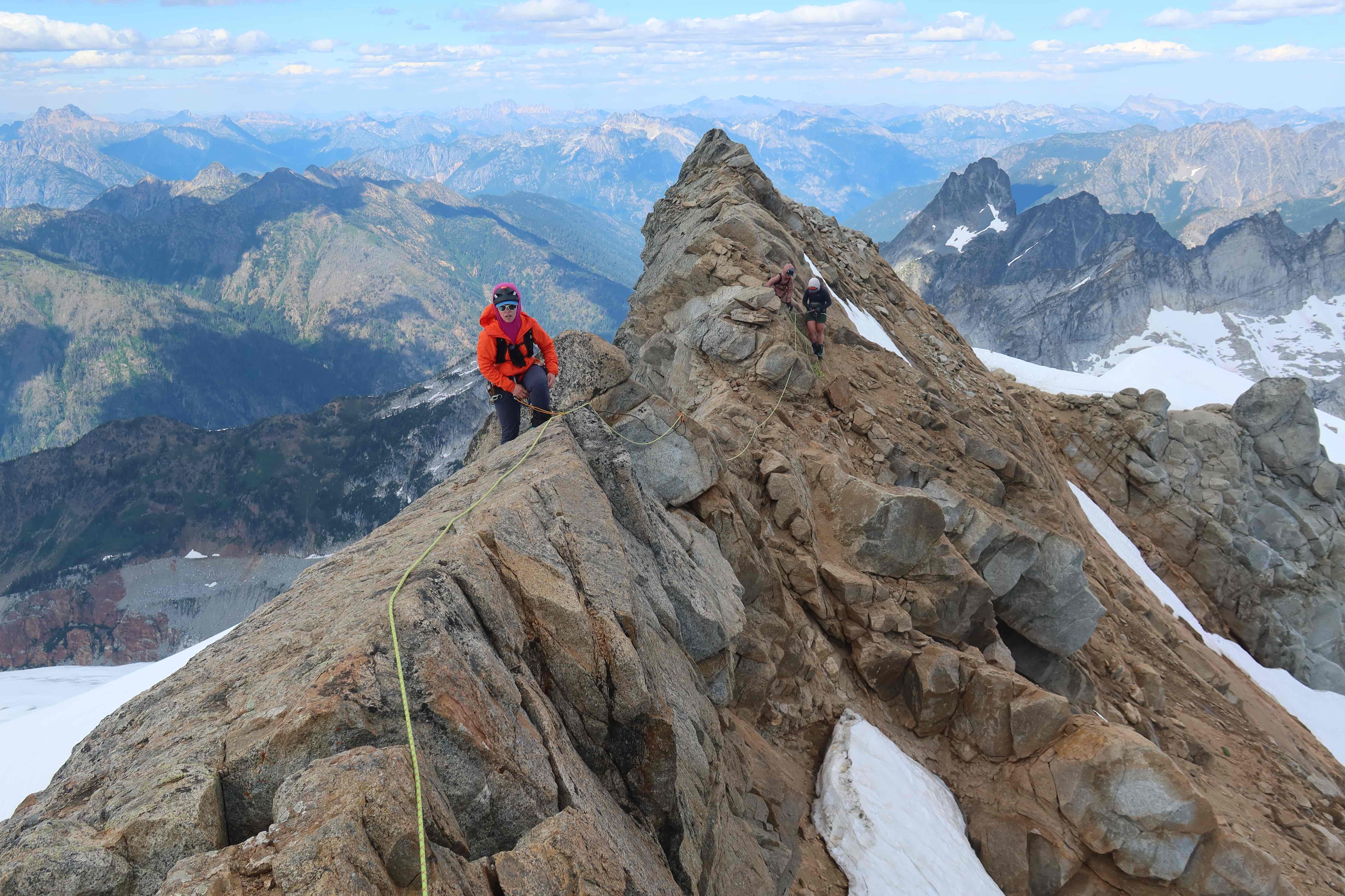
The multipitch sequence makes sense when moving through a long stretch of terrain (hundreds of feet) with serious fall-hazard, as most rock climbs do (and we’ll get to that multipitch sequence later,) but on some climbs / some situations, there can be a shorter stretch (e.g. less than 200′, or even <100′) of terrain with serious fall-hazard which we protect with a “fixed-line”, such that the rope has a static connection to anchors at either end, the rope does not move, and climbers travel along that fixed-rope.
I climb a lot in Washington’s Cascades, and I do a lot with the Seattle Mountaineers. So, often enough, I end up having to manage a group in terrain that’s a little too high on difficulty or exposure to be something I’d want to scramble unroped, but not long or hard enough to treat like a full-on multipitch rock climb either. This middle ground can be an excellent time to make use of a fixed-line, particularly if your group-size is any larger than a party of two. By “fixed line”, I mean a situation where you or someone in your group has taken a climbing rope, and fixed it in place, with a hard-knot to an anchor at at-least one end, though almost-always preferably both ends. The rope doesn’t move, but people move along it.
I like to call the setups in this post “fixed lines.” I’ve also heard people use “hand lines” and “static lines” as synonyms. The problem with those other two terms is that they’re overloaded, they’re both terms that have second meanings. A “hand line” may also refer to a rope that you simply grab with your hands but that you’re not connected to at all, where it’s not exactly PPE (Personal Protective Equipment.) I think of those “hand lines” as retired climbing ropes tied around a tree on some cragging approach with a scramble move where having something extra to grab is really helpful, but not there as technical fall-protection. A “static line” may also refer to a category of rope-construction, ropes that are built to behave as static (e.g. for hauling, or rescue) and not dynamic (as ropes built for catching falls & absorbing energy must be.) It is too ripe for confusion to say “let’s use a static line” while the rope you’re using is constructed to be a dynamic rope. So I suggest we all call these setups “fixed lines” 🙂
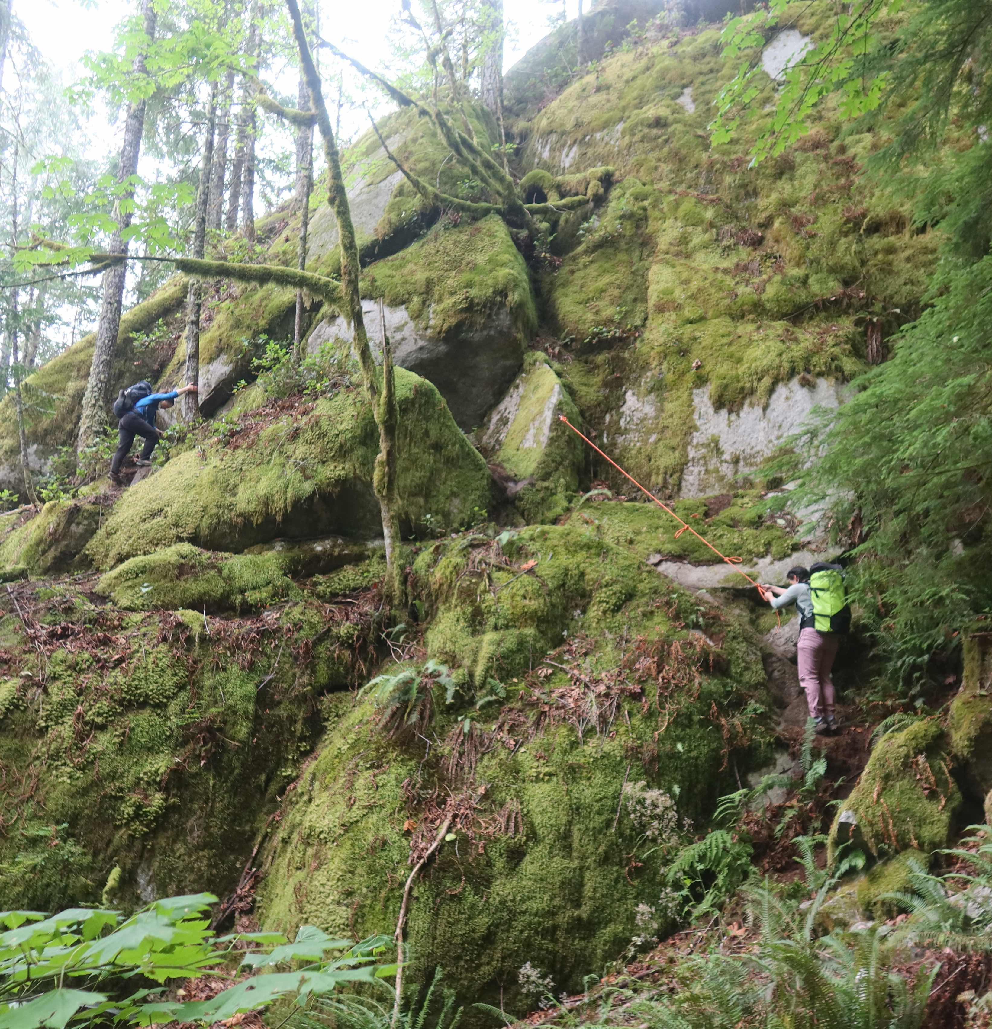
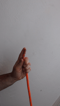
When someone says “hand line”, I might think of a rope like this orange one, that’s not intended to be technical PPE, it’s just something to grab with your hands to assist through a scramble move that may be annoying, but doesn’t necessisarily need protecting.When someone says “static line”, I might think they are refering to a specific type of rope-construction.
As the leader: Setting up a fixed line
Connection at the Anchor
My favorite way to connect a fixed-line to an anchor is to have a clove-hitch on a locking-carabiner positioned to actually hold any loads, but with enough tail on the slack side of the clove-hitch that I can tie a figure-8 on-a-bight in that tail as a backup knot, and clip that to the same anchor with a separate carabiner. You don’t have to do it this way, you could use any climbing knot designed to hold a load (e.g. figure-8, bowline, alpine butterfly, etc.) But the big advantage of using a clove-hitch is that a clove-hitch can be much easier to untie after having been weighted. Later when taking down the fixed line, after multiple people may have weighted it, as long as you can push the clove hitch off the nose of the carabiner it was on, the knot just goes away, you don’t have to fight to untie it. Also, for neatness points, try to clip your clove-hitch so the the load-strand within the hitch is closest to the carabiner’s spine.
Don’t want to carry a ton of lockers into the alpine? Before setup, ask each member of the party to contribute one locker towards anchoring the fixed-line, and suddenly you’ll have plenty of lockers. Or, remember you can always make a locker out of two opposite-and-opposed non-locking carabiners. Or, depending on your risk-tolerance, it could be a judgement-call as to whether the backup knot’s separate carabiner is locking carabiner or a non-locker.
Is that backup knot & it’s second carabiner even necessary? If we are theory-crafting, in theory that backup knot will never see any load. In practice though, backups are a really good thing. Humans make errors. Every so often I see someone who thought they tied a clove, but actually tied a munter-hitch; yikes!! Or maybe the clove is tied successfully, but the gate of that locking-carabiner gets dragged against rock in a really unlucky way that unscrews it and pushes the gate open. In my opinion, it’s worth throwing in a backup knot every time. Plus, if you train yourself to do the backup knot every single time, it ends up taking less time to just add the backup knot than it would to stop and ponder the decision “should I do it this time or not…?”
Gear necessary for a fixed line
Group gear:
any climbing rope. If I’m on an alpine climb where I’ve brought a rope for some other purpose, I’ll just use whatever that rope is. If it’s an objective where I’m only bringing the rope because of this fixed-line, I’ll tend to opt for a skinny rope to save weight, (e.g. a rope vaguely in the ballpark of 8.0mm diameter, and it’s okay to use a single strand or rope that’s rated “half” or “twin”, since it’s scramble terrain, not some vertical upper-fifith-class, so it’s not going to have to catch any big falls.) I’ll research pretty hard to find out what length of rope is necessary to protect the section I’m aimign to use it for. If no such beta is available, I may default to brining a 60-meter rope. Often longer is better, so that one stretch of fixed-line can actually reach where you need it go. There’s plenty of cases where you can make things work with a shorter rope, or tie two 30-meters together to make 60 meters, but shorter ropes risk more shenanigans, and possibly even time-delays, if you have to set it up more than once to cross a longer distance.
two cordelettes, or any material to make two anchors out of
four locking carabiners, since there’ll be two knots on separate carabiners at each of the two anchors (optionally, you could use non-lockers for the backup knots)
on a case-by-case basis: maybe a small amount of trad gear, extra slings, maybe even pickets, etc.
Personal gear: (every person who’s going to utilize the fixed line should have…)
a hero loop: At least one hero loop. (a small loop of cord they can make a prusik out. 6mm accessory cord tied with a double-fisherman’s knot so that the loop is about 1’3″ end-to-end works really well. A a cut single strand of 6mm cord about 4’3″ long will form about the size loop you want.) As a rule, I always always always carry two hero loops on the back of my harness no matter what kind of climbing I’m doing, and I rather think that everyone else should do the same.
a personal anchor / personal tether
at least one locking carabiner, though having two or more is probably more convenient
optionally, a long prusik loop, like the “waist prusik” piece of a texas-prusik set. (e.g. a 7-foot straight section cut of 6mm cord, then tied into a loop, will form a nice length for a “long prusik”)
Setup Sequence
Before setup, the preparation:
The first & trickiest decision is to decide where the fixed-line should go. Particulary, where exactly to put your first anchor, and thus start your fixed-line from. Prior research & beta helps a lot here. Otherwise: if you know where you need to go, and where the location of the fall-hazard of concern is, you’ll have to eyeball how close to all that you’ll need to be for your length of rope to entirely reach. Then, search for something that can actually be used as an anchor. Anything you might use as an anchor in the alpine is valid: a rock horn you could sling with a cordelette, or a buried picket, or multi-piece trad anchor, etc.
I, as the rope-lead who is going to set this up, will gather enough gear from everyone else so that you’ll have enough for the anchors at both ends, the locking carabiners, etc.
I’ll build the anchor for this starting-end of the fixed line. I’ll recruit a belayer, and have them flake the rope right next to the anchor.
I’ll talk through the setup-sequence I’m about to use with my belayer, so they know everything to expect, before I get further away from them.
The setup sequence that I typically do is fairly similar to the multipitch sequence, but modified slightly so that I, as the rope-lead setting this up, am personally doing all the anchor-building and rope-connecting, so that I am in control of each part, I know it’s all done the way I want, and I don’t have to having a distant-yelling-conversation with someone else about how to do a step.
Fix the “bottom” end of the rope. Rather than have the belayer tie-in to a rope-end, instead I’ll affix the “bottom” rope-end directly the anchor I’ve just built. I want a clove-hitch on one locking carabiner ready to hold the load, and a long enough tail beyond that clove-hitch that I can tie a figure-8-on-a-bight and put that on a separate carabiner, also directly affixed to the anchor. It may be easier to tie the figure-8 first and the clove second, guaranteeing the tail length is right on the first try.
Next steps are exaclty like the normal multipitch sequence for a while: I, as the rope-lead, tie in with a re-woven figure-8 on the “top” rope-end. I have my belayer connect themselves to the anchor (since they’re not tied into the rope, they’ll have to use a PA, or perosnal tether, and a locker to connect themselves to the anchor.) I have my belayer put me on belay.
We do our safety-checks of eachother, and have the “On belay?” “Belay on!” conversation.
I’ll lead out, placing leader-pro if that’s relevant to the situation here.
End the pitch: When I arrive at the place where I want the fixed-line to end, I’ll build the anchor that’ll go there, clip in with my PA/personal-tether, and shout “Off belay” to my belayer, and wait for them to respond with “The belay is off.”
Getting slack out: It’s likely that the climbing-rope I’m using is longer that I need for the fixed-line setup, but I do want to get that slack out. Before I affix the rope to this second anchor I’ve built, I’ll pull any extra slack over to me, and flake it on the ground near me. Before-hand, I’ve asked my belayer to watch for the rope to come not-quite-tight to the original anchor, and when it does, they just shout “That’s me!!” but not change anything about the anchor they’re at.
Now fix the “top” end of the rope. Once I have all the slack near me, and my belayer has told me that I’m more-or-less pulling on the other anchor, I’ll let a tiny bit of rope back out (just a foot or so, so it’s not taught) and then finally affix this side of the rope to the anchor I’m at. Again, a clove-hitch on a locker positioned to hold the load, and a figure-8 on-a-bight on a second carabiner as a backup knot.
Tell people the rope is fixed and ready for them, and they can put their prusiks or PA’s or whatever on it, and climb when ready.
If the plan to is for people to travel back across the fixed line back to the start in the fairly-near-future, then when they arrive at the end, they don’t have to undo their prusik-hitches at all, they can simply unclip from them. When it’s time to prusik back, they just clip back in to their prusik. That saves the time of having to re-do them. Though it does mean that people have to travel in last-in-first-out order on the return trip to get to use their own prusik hitch.
Later, when it’s time to take down the fixed-line: I’ll send everyone but me back to the 1st anchor, so I’m alone at the 2nd anchor. I’ll tie back in with a rewoven figure-8 using the “top” end of the rope. Once everyone’s off the fixed line, I’ll take out the clove & figure-8 that had been affixing it to the anchor. I’ll have my belayer pull all slack to them, until I say “That’s me!”, then they’ll put me back on belay. I’ll clean this 2nd anchor, and have them belay me as I climb back to the 1st anchor.
Obviously, (like everything in climbing), this certainly not the only sequence or way to setup a fixed line. There are thousands of right answers. This is just the particular sequence I’ve settled on using myself, because it offers me so much control over so many pieces, which is useful when I’m the more-experienced person taking out less-experienced climbers.
Moving on a Fixed Line: Three Categories
What should the participants do once the fixed-line is setup? Broadly speaking, fixed-lines setups fall into one of three categories, which I’ll call: horizontal, sloped, and vertical. Each category has different rules about how people can safely move along it.
Horizontal
(a) Traveling along a horizontal fixed-line, where the climber’s connection is their PA and a locking carabiner to the rope. (Slides easily, which is both a pro & con.)
Sloped
I’m using the word “sloped” because I wanted a single-word that was easier to say than saying “for all those slope-angles that aren’t horizontal and aren’t vertical.”
(b) Traveling along a sloped fixed-line (or a vertical one where good climbing holds are available,) where the climber’s connection is a prusik-hitch to the rope. (Ideally, extend your connection using your PA and a locking carabiner to clip that prusik.) Similar to this video: https://www.youtube.com/watch?v=_8IwhJUjkd8
About ascending a vertically-hanging rope: About half the students have glacier-travel experience and have done this before. However, in the glacier travel scenario, people carry different prusiks in specialized lengths specifically for doing this, and that’s not a piece of gear we typically have on a rock climb. Instead, focus on improvising a way to ascend a vertically-hanging rope using only the gear that was required on the Course Gear List. One option for a setup I would encourage:
attach your Hero Loop to the rope as a 3-wrap prusik
use your PA, and clip into that prusik with a locking carabiner. So far this setup serves as the equivalent to the “waist prusik” from glacier travel.
If you have a second hero loop (everyone should now, since one was required in the gear list, then I gave out those orange ones as a second one to everyone,) also attach that 2nd hero loop to the rope (below the first one) also as a 3-wrap prusik.
Take a double-runner, and girth-hitch it around one of your boots. Slide your hand up that double-runner to about the height of your knee, then tie an overhand in it to create a clip-in point. Clip that to the 2nd (the lower) prusik hitch that’s on the rope (this carabiner can be a non-locker.) This setup serves as the equivalent to the “foot prusik” from glacier travel.
As you ascend, add backup knots on the climbing rope itself below you, so that something would catch you if a prusik fails. You can do that “rolling clove” strategy, or you can keep accumulating multiple figure-8-on-bights on a big locking carabiner on your belay loop.
This video shows a lot of this really well: https://www.youtube.com/watch?v=CKOZDe0J4bI But note there are some differences between what she does, and what I’m recommending. First, she uses different types of friction hitches. (“Friction hitches” are a broad category, and specific types of friction hitches include the prusik and the autoblock which you’ve learned, and also the klemheist, which I wasn’t intending to teach in this course. Also, she uses the term “French Prusik”, which is actually just a synonym for the autoblock hitch.) I’d recommend using simple 3-wrap prusiks for both friction hitches, instead of what she’s doing. Also: You’ll almost certainly want more extension between the higher-prusik and your harness, thus my recommendation to extend it a bit with your PA.
If you clip bolts outside, here’s some base knowledge you should have about the bolts you are clipping, and what to look for.
Keep in mind that almost every bolt you clip outdoors could be described as “abandoned hardware on public land.” You should be treating them with the same mindset you use for webbing rappel anchors that you happen to come across. Someone put it there, maybe recently, maybe long ago; maybe they used great materials, or maybe they used materials that weren’t designed to last; maybe the years have been unkind to the material and it has degraded. (For webbing rappel anchors, “degraded” could be UV-light bleaching, or getting chewed on by a rodent, etc. For bolts, the concern is rust, or mechanical parts loosening.) In any case, the person who put it there is long-gone, and it is your responsibility as the person who is here right now, about it use it right now, to be able to inspect it a little bit, and be able to make a judgment call about how much to trust it. Yes, there is a difference between webbing rappel anchors and bolts, in that webbing rappel anchors are quite simple to replace, and anyone carrying a bit of spare webbing or cord can do so; whereas bolt-replacement-work is highly technical & involved, requiring specialized-tools, specialized-skills, and an immense amount of time. But at least being aware for the state of a bolt is still an important skill, and may change how you choose to use it, or what you would tell others about it, even if you cannot change the bolt at the time that you’re using it. Hopefully, this post gives you a little more awareness about what you could/should inspect, as a user of existing bolts.
For even more information, you could check out HowNot2’s bolting bible, which is an absolutely phenomenal resource, and probably more accurate than anything I describe here. But I also know it’s a lot, more than someone who just clips bolts probably wants to read. I’m hoping my page here is a less-overwhelming amount of information to absorb, targeted at an audience that clips bolts, but isn’t in the business of placing bolts.
Parts of a bolt
As a climber, you are used to seeing the part of the bolt that is outside of the rock, such that the bolt looks something like this:
However, to have a better awareness & understanding of the bolts you are clipping and trusting your life to, you should at least be able to name & identify the separate parts you are seeing here: the bolt’s hanger, vs shaft, vs nut.
With any belay device, you should never let go of the brake strand. But if someone fucks up, or the belayer is injured, then belay devices with assisted-braking provide an additional layer of safety towards not-dropping the climber.
The moment that really convinced me personally was long ago in my climbing career, when I was climbing at the gym with a relatively-new belayer who was notably lighter than me. I took a fall, and that particular belayer was lifted of their feet, and slammed into the wall, and in that split-second, reflexively and without thinking, they put their hands up to take take the impact of hitting the wall. Both hands. Neither hand remaind on the brake strand. Fortunately, they were using a belay device that did have an assisted-braking feature, and it had happened to engage, catching me. Thank goodness the incident had no physical consequences, and it was thanks to slight extra margin of safety that assisted-braking layers on. The only consequences were emotional, the belayer was indeed mortified that they had let go of the brake strand–of course they knew not to do that, and they felt horrible that it had happened. But I also understand that it had all happened so fast & suddenly, that it had nothing to do with what the belayer knew, or thought, or chose; it happened fast enough that there was no knowing, no thinking, no choosing; just reflex. My takeaway is that humans should strive to do the best job they possibly can, but we should also acknoldge that humans inherently imperfect and that mistakes are inevitable, so it is better to engineer in systems that have at least some fault-tolerance. i.e. strongly prefer that what you get from your belayer is both excellent belay technique, and an assisted-braking belay device. One-in-a-million things do happen, all you can do is try to change the denominator.
I’m also going to go out on a limb and make a prediction for the future of climbing: Although belay devices that lack assisted-braking are common today (e.g. Black Diamond ATC, Petzl Reverso, etc.) I strongly suspect that in 50 years, climbers will look back at belay devices that lack assisted-braking the same way we currently look back at hip-belays in the 1960’s, thinking “Geez, that was so risky! I can’t imagine taking a risk like that!” That new realization hasn’t yet swept the climbing community, but I predict it’s coming, so why not get ahead of it and add that extra margin of safety? If you want to really geek-out on this, there’s a fantastic & very long article from the AAC on this topic. Also, some gyms have already taken this step!
Why specifically the MegaJul?
I care more that you use some belay device with assisted-braking, any device with assisted-braking. I don’t care so much which specific assisted-braking belay device you choose. For example, if you want to belay me with a Petzl GriGri, that’s fantastic, I will be perfectly happy!! Bring that GriGri to the gym, the crag, or the alpine, it’s great in all settings! I certainly do know a lot of fellow climbers who do indeed carry their GriGris into the alpine for any climbing they are doing. However, pretty much all climbers care about weight, and often ask the question: “But what is the lightest thing that can work?” The GriGri’s most notable downside is that it weighs 175 grams (or 6.17 ounces,) compared to a MegaJul, which weighs 75 grams (or 2.65 ounces.) If for some reason you carried two MegaJuls, together they would still be ligther than one GriGri. The GriGri’s second big downside is that it cannot do normal rappels, on two strands of rope. (Yes, you could do single-strand rappels with the GriGri, but the extra setup to make every rappel a safely a single-strand rappel means you’ll eventually lose on speed.) Everyone I know who brings a GriGri into the alpine, also chooses to bring a second belay device which for them is dedicated to rappelling. A Black Diamond ATC is great for rappelling, but carrying both a GriGri (at 175 grams) and a Black Diamond ATC (at 80 grams) is a lot of weight to achieve both assisted-braking belaying and normal rappelling; whereas a single MegaJul (at 75 grams) can do everything a Petzl GriGri and Black Diamond ATC combined can do, and is the lighest thing on the market that can do so.
The downside here
The biggest downside of specifically the MegaJul is that it does have a steeper learning-curve than most belay devices. Since it takes a while to learn the nuances of working with it smoothly, many people try one out for a short time, and during those early times they use it before they’ve learned the nuances, it feels a jerky & grabby & difficult. Many people aren’t willing to stick with it long enough to get through the learning curve, and they blame the device (“Oh the device is jerky!”, despite the fact that it’s not jerky in the hands of an experienced user) rather than take on a learning mindset (“How can I hone my skills so that I am able to utilize this device more smoothly?”) Anyway, I do sympathize, the learning curve for the MegaJul is indeed notably longer than most popular belay devices, and it does suck to be within the learning-curve rather than past it. You need to practice the parts of this article that are relevant to you and your type of climbing. If you’ve never used this style of belay device before, you are going to be awkward and clunky the first few times you try these skills, and that’s okay, that’s normal. But if you stick with it, keep practicing, build muscle memory, and notice the little details that make things smoother, the payoff is that you’ll have a tool that does everything an ATC does and everything a GriGri does, for only 75 grams. And your partners will appreciate knowing they’re belayed with an assisted-braking belay device, as long as you have developed your skills to operate it smoothly.
I have learned to operate the MegaJul very smoothly, and I’ve found it to be an ideal & effective device for me. I’ve gotten past it’s learning-curve, and I’ve clearly learned some nuances & tricks that make it work so well for me. I really wish I could communicate those nuances to you, to make the learning curve a little shorter for you. This article is my best attempt to capture some of those nuances.
What To Buy / Some Specific Gear Recommendations
TODO: Why specifically the MegaJul, and not he GigaJul or just the Jul.
TODO: talk about carabiner-choice
Core Belaying Skills
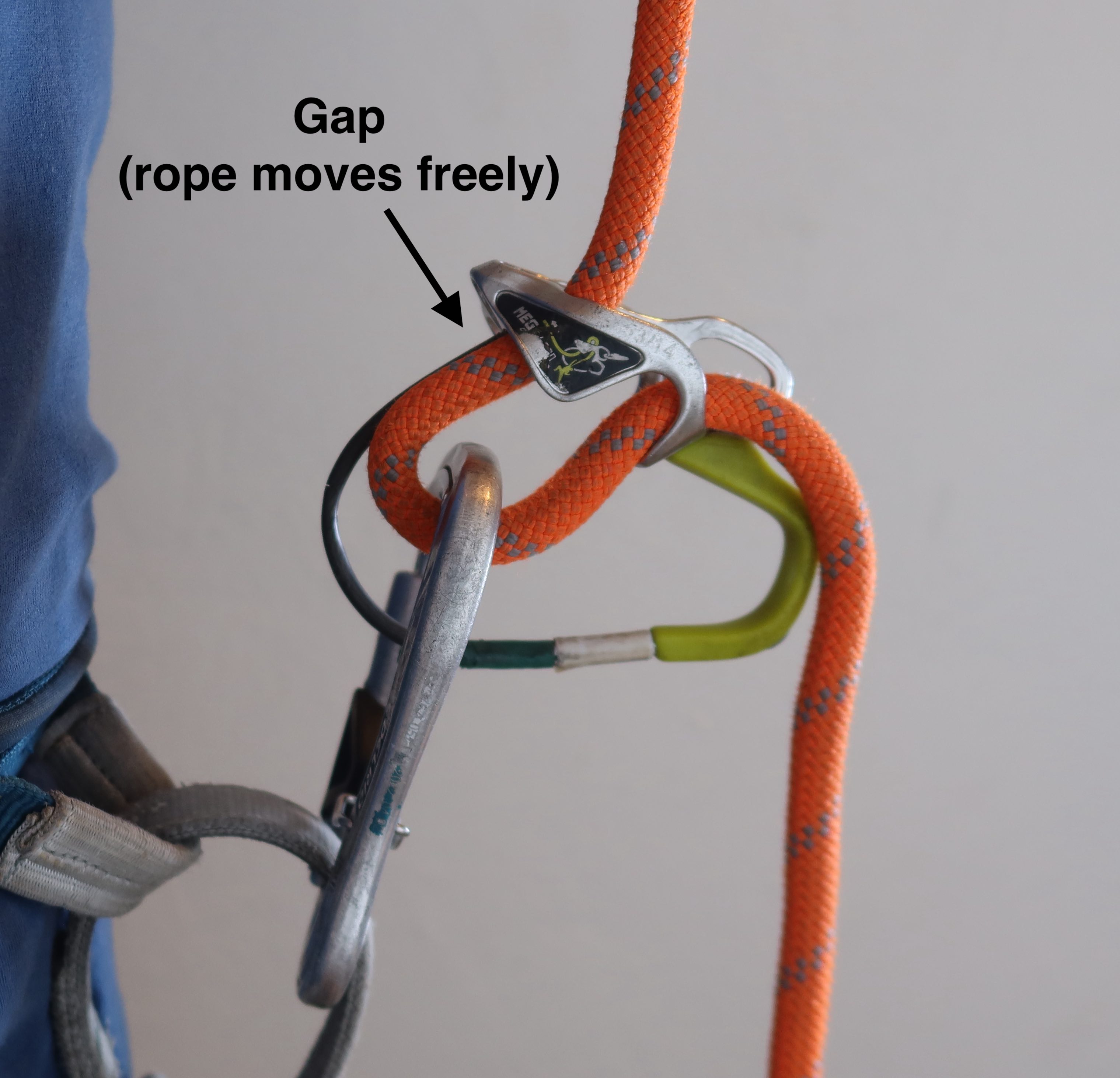
Notice the Gap!
The first thing you should learn about the MegaJul is how it’s accomplishing it’s assisted braking. It does so via the geometry of the device, with that notch in the bottom. When a carabiner gets sucked up into this notch, it pinches the rope. Therefore, the difference between rope moving freely through the device, vs being pinched, is based on whether there is a gap of open-space between the MegaJul and the carabiner or not.
Baseline
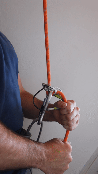
When belaying off of your harness, Edelrid advises that any time the rope isn’t moving but is unweighted, you should assume the “baseline” position, which is the ideal ready-stance for the belay motion that’s likely to happen when the rope does move. The baseline position involves a brake-hand with four fingers closed around the rope, and the thumb of that hand through the lime-green thumbloop. A slight forward tension from your thumb both holds the device up to create the gap between the device and the carabine, and pulls the MegaJul so it’s pitched 90-degrees forward, such that the mouth of the MegaJul pointing forward, away from your belly-button. This position both allows the rope to move freely when you choose to move it, and is also the position that’s most likely to cause the assisted-braking to engage quickly and closest-to-automatically if a fall from the climber jerks the rope upward.
I’ve noticed that I use two versions of the “baseline” position, depending on if it’s top-rope climbing (and the likely next movement is reeling rope in) or if it’s lead-climbing (and the next likely movement is paying out slack for a clip or upward movement.) The only difference between these two versions of baseline is where I put my secondary hand: when top-roping, I rest my hand high on the rope, so it’s ready to pull down. When lead-belaying, I rest my hand low, just barely above the MegaJul itself, so it’s ready to pull up.
Belaying for Top Rope
Belaying for top-rope with a MegaJul use the standard PBUS technique that’s taught for nearly all belay devices these days. I assume you already know PBUS, but jus tin case, here’s an excellent 4 minute video demonstrating it: https://www.youtube.com/watch?v=FCUJrXSKWrw Just do exactly that, but with a MegaJul.
PBUS: Pull, Brake, Under, Slide
Tips for smoothness:
Note that the gap is maintained throughout, so the rope is free to move.
Simultaneously pull rope the climber’s-side rope downward at the same time as the brake-hand is pulling rope through the device, so that the subsection of rope passing through the MegaJul is never in tension during this motion.
If you feel the device “grab”, it’s because the gap got closed. A useful skill to practice is getting your thumb back in the thumbloop without having to look at it, so that you can pull up, re-create the gap, and get back to smooth rope movement quickly.
If your climber pauses and you’re no longer pulling in rope, go back to baseline, with your thumb in the lime-green thumb loop. However, you don’t need to return to this baseline unless the rope stops moving. If your climber is climbing as fast as you can belay for the entire route, you may never put your thumb in the thumb-loop during that top-rope belay (until the moment the climber needs to lower.)
Lowering a Top-Rope Climber
The key to providing a smooth lower with the MegaJul belaying from your belay loop is to push forward with your hand that has a thumb through the thumbloop. Push forward (away from your belly-button,) and possibly even a little bit downward (angling the forward every-so-slightly towards the ground.)
Avoid lifting the device upward. Yes, lifting the device upward will re-open the gap, and allow the rope to run freely, and some other instructionals about the MegaJul will even tell you to do that. However, if you life the device upward and re-open the gap, the rope will run quickly for a split second thanks to the gap, in fact quickly enough that it’ll suddenly re-close the gap too, suddenly slowing the rope, at which point since your hand is still applying a lifting force the gap re-opens… you see how this leads to a bouncy & jerky lowering experience. So to lower, don’t lift the device upward, instead push it forward.
As you push the device forward, the MegaJul will pivot against the carabiner just enough to let the rope start to move a bit. Find that sweet spot, and try to hold you hands there. I try to half-control the lower with the angle of the device, and half-control the lower with the firmess/looseness of my grip on the rope.
For bonus points: you can guard the spot on your hand that would feel the most rope-friction (the spot at the base of your thumb that the rope would curve over just before it enters the mouth of the belay device) by carefully positioning the lime-green thumbloop plastic to sit right there, thus having the highest-pressure part of the rope run on top & parallel with the plastic, rather than on your skin at that point.
Belaying a Lead Climber
Belaying a lead climber uses all the skills you already know for belaying a top-rope climber, and then adds the need to pay out slack quickly at times (either for the climber moving upward, or going for a clip.)
As with all devices, when pulling slack, your brake-hand stays on the rope, but loosens it’s grip slightly, just enough that your brake hand acts as a tunnel for the rope to pass through. The key to paying out slack is to maintain the device’s gap the whole time by actively pulling up with your brake-hand’s thumb on the thumb-loop. As your secondary hand pulls slack through the device to give to your climber, that pull is creating tension in the subsection of rope within the device, and that tension will try to close the gap, which would pinch the rope.
Another thing I find key to lead-belaying with any belay device: always immediately reset your secondary hand to be just-above the device as quickly as possible. That reset of the hand puts you in the position where you’re ready to pull again, and give a second arm-load. If you don’t intentionally practice this and build a muscle-memory around doing this, the unfortunately-intuitive thing that people otherwise do after pulling an armload of slack is leave that secondary hand out there fully extended, where it’s not ready to pull again. Then, when the next armload of slack is needed, they’re behind, they have to move that secondary hand close again before they can start pulling another armload.
This, especially, takes deliberate practice to get smooth at doing reliably and quickly. Put some time into practicing it!
Tips for smoothness:
To repeat the key point above: Maintain the gap! If the gap closes, assisted-braking will engage and stop you from paying out slack until you re-open the gap.
Rope preparation is also key! Have a well-flaked rope, so that you do not end up with any unexpected tension coming from trying to pull a tangle out of the rope pile, as that tension will make it likely that the gap closes.
Anytime I have a free moment while lead-belaying, I pull a few armloads of slack out from the pile of rope and drop them by my feet, just to make sure that the upcoming rope which I’ll need to pull does indeed pull freely. (Obviously: pull these armloads out with your secondary hand or something; you are not ever letting go of the brake-hand to do this.)
Practice, practice, practice! You’re not going to be smooth at this at first, but smoothness will come in time, as long as you actually put the time in. At first, you could practice at home by flaking a rope in your living room, then imagine you’re giving someone a lead-belay, and practice paying-out slack through the MegaJul simply into a pile on the floor. Later, when you’re going to give a climber a lead-belay with the MegaJul for your first time, talk about it with them before they climb: it would make sense for them to lead something juggy & easy-for-them that they feel totally confident on while you’re still working on getting smooth with this device, where they’re comfortable pausing for a moment if you accidentally short-rope them. After you’ve gotten some deliberate practice in and become smooth, then the MegaJul is an excellent belay device for your partner to try leading that project of theirs at their limit, but you’ve gotta put in the practice before that.
Rappelling
First, a brief soapbox that’s not specific to the MegaJul: For any & every rappel in a climbing-context, with any device, I strongly advocate for always following Rob’s Three Rules for Rappelling:
Always put knots in the ends of the ropes. (A triple-fisherman, or barrel-knot, in each rope-end is a great choice.)
Always use a system that will stop if the rappeller lets go. (An auto-block is the most common answer. Receiving a firefighter’s-belay is another valid solution.)
Always test before you trust. (Before unclipping your PA, make sure there is slack in your PA, and put your weight on your whole rappel setup, then unclip the PA.)
Triple-fisherman’s knot, barrel knot, stopper knot; whatever you want to call it. Just make sure there are indeed knots in both ends of your rappel ropes. This is not a MegaJul thing, this is a general rappel safety thing. In terms of speed: I notice that it takes me less time to just always automatically tie a stopper knot without questioning it, than it would for me to pause and think “Do I really need a stopper knot on this rappel…?” Also, here are even more thoughts on safety in practice.
Standard Rappelling – with Assisted-Braking Disabled
With the MegaJul, the rappel setup that I both recommend & use the most is an extended-rappel, in a setup that results in the MegaJul’s assisted-braking-feature being disabled (so that it acts just like a Black Diamond ATC or Petzl Reverso would,) then adding an autoblock friction-hitch to satisfy Rob’s Rule #2. This is essentially a vanilla extended rappel setup, just like what’s shown in this video, except done with a MegaJul. Any time I’m doing multi-pitch rappelling, this is the setup I use.
The key to disabling the assisted-braking is positioning the lime-green-thump-loop Up and In. Notice how the device has been rotated 180° around the yaw-axis, so that the green thumb-loop points inward towards my own body, making the thumbloop opposite from the brake-hand-side of the rappel rope.
Extended rappel with the MegaJul set up so that assisted-braking is disabled. The gray webbing with the black stripe is a Personal Anchor here, with a knot it it that’s clipped to form the rappel extension.
Here’s a slowed-down step-by-step on how I set up the MegaJul for rappelling with the assisted-braking disabled:
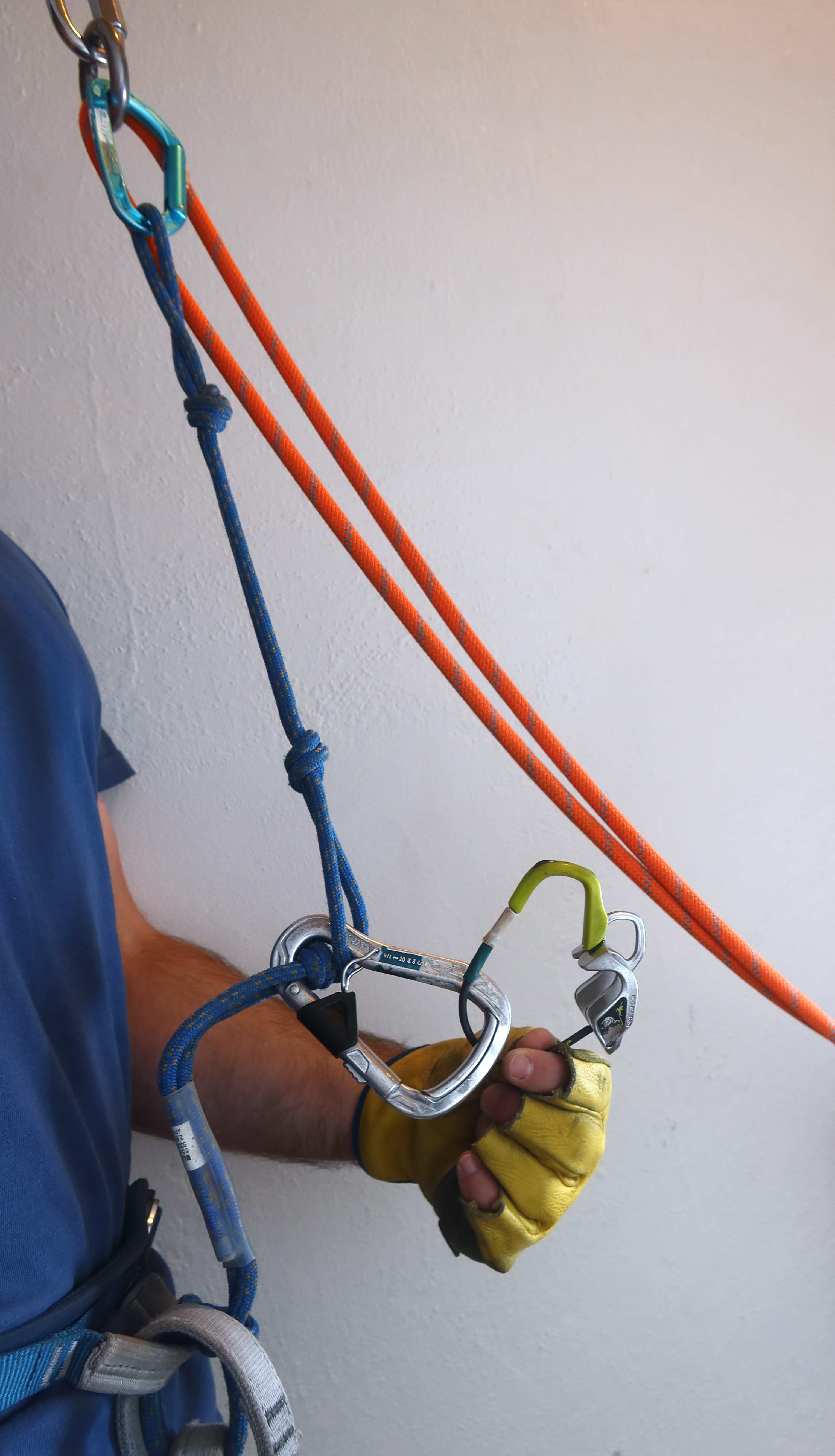
#1. Clip my Personal Anchor to the rappel anchor. (In this photo, the blue cord, and blue locking-carabiner, are my Personal Anchor.) Clipping the rappel-ring itself is ideal if there’s space. Clipping low on the anchor like that sets you up to have slack in your PA, and you’ll need slack in your PA in order to proceed with the setup, and the slack is also helpful later when you test that your final rappel setup holds weight. (Sorry, the slack isn’t shown well in this photo.) Having slack in your PA works best if the rappel anchor is somewhere you can stand comfortably, keeping your PA unweighted. If, however, you’re at an anchor where there’s a poor stance, and you must hang from the anchor, then you’ll need to use either a second PA, or a quickdraw or short sling, that’s clipped somewhere higher on the anchor that does hold your weight, so that your original rappel-extension PA remains slack. (And for those who are curious: what I’m using as a PA here is a “BlueWater Sewn Prusik Loop“, 6.5mm diameter, 44-inch loop length, which I’ve connected at my harness hard-points with a bowline-on-a-bight (a girth-hitch also works and is simpler, but I like that the bowline-on-a-bight doesn’t squeeze the hardpoints together), and then I’ve tied a series of overhand knots in the loop to create multiple length-options for clip in points. This just happens to be the PA I’m using in these photos, you can use any other PA or anything you’d like to create the rappel extension, there are a thousand different right-answers for creating rappel-extension out there, and I simply happened to pick this one to illustrate with here.)
#2. Attach a locking carabiner to your rappel extension. Put the MegaJul on that locking carabiner, so that it’s ready for later, but don’t necessarily do anything with the MegaJul yet. For neatness points: make sure the lime-green thumb loop is UP and IN when you clip it to that locker.
#3. Put an autoblock hitch on the rope, and clip it with a locking carabiner to your belay loop. By putting the autoblock-hitch on first, it can hold the weight of the rappel ropes for you, giving you unweighted slack to work with above the autoblock, which makes the upcoming steps easier. (If you’re curious: the green locking carabiner shown here is an Edelrid Pure Slider, a favorite of mine since it is a very lightweight auto-locking carabiner, very quick to open & close, which helps with efficiency. Also in this picture, the material I’m using for an autoblock happens to be a “Sterling Hollowblock”, the 13.5-inch one, but you could use any hero-loop / prusik-loop. I very frequently use simply some 6mm accessory cord, originally cut as a 4’3″ length of straight cord, then tied into a loop with a double-fishermans knot, which results in a loop that’s ~15″ end to end, which I find to be an ideal size.)
#4. Next, it’s time to push the pair of rope-strands into the MegaJul, and clip them with the locker. Pay careful attention to the positioning of the MegaJul’s thumb-loop here: the thumb-loop should be UP and IN, such that the brake-strands of your rappel-setup are on the opposite side of the device from the thumb-loop.
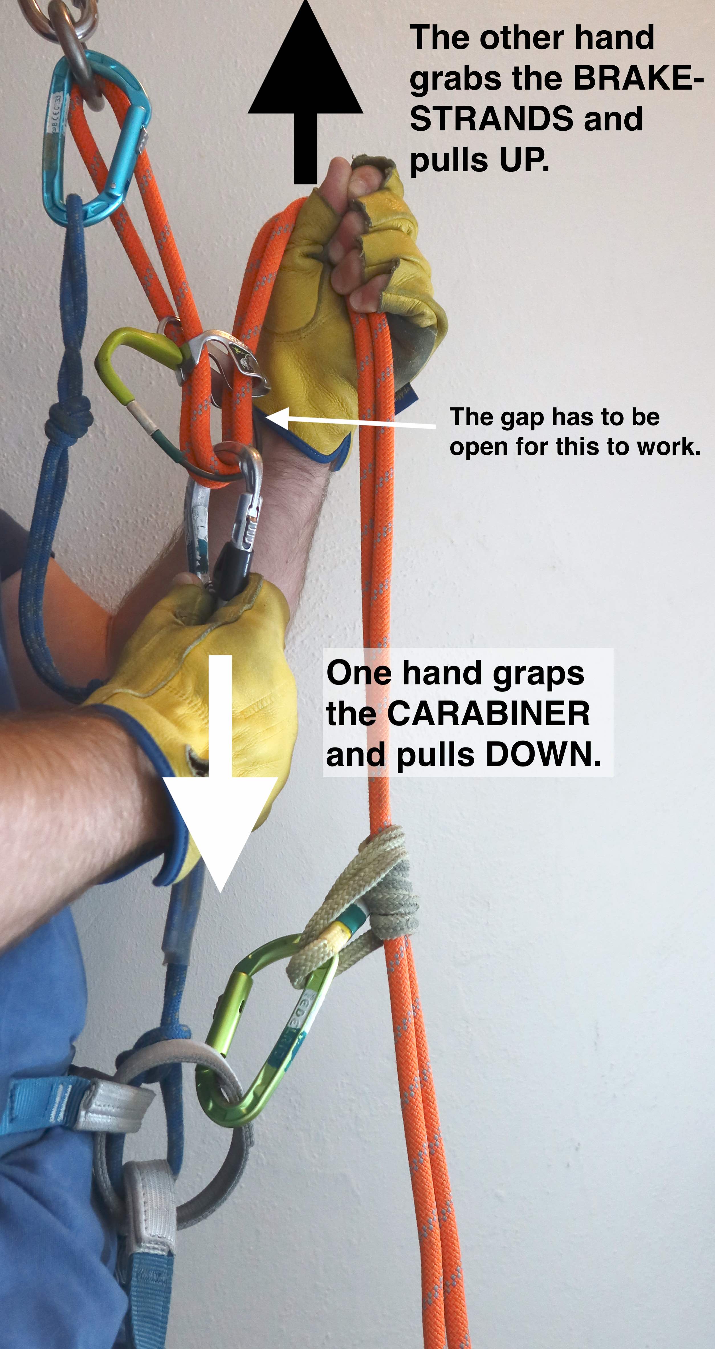
#5. Okay, you’ve built your complete rappel setup, but you still need to test it. The point of the test is to simply verify that the rappel setup holds your weight and stops automatically, before you unclip the safety of your PA. You need quite a bit of slack in your PA to be sure that you’ve actually tested that it is the rappel setup holding you, and not some tension in your PA. In order to create as much slack as possible in your PA, you’ll need to move your rappel device backwards up the rope, getting your rappel-device (the MegaJul) as close as possible to the anchor’s rappel ring. The first small-step to moving the MegaJul backward on the rope is to lift it, and re-create the gap, so that movement will be possible.
#6. Once you’ve created the gap, and movement is possible, then take one hand and grab the locking-carabiner, and pull down, and take the other hand and grab the brake-strands, and pull up. As long as the gap is open, this will smoothly pull rope backwards through the MegaJul, getting the MegaJul up as close as possible to the rappel-ring.
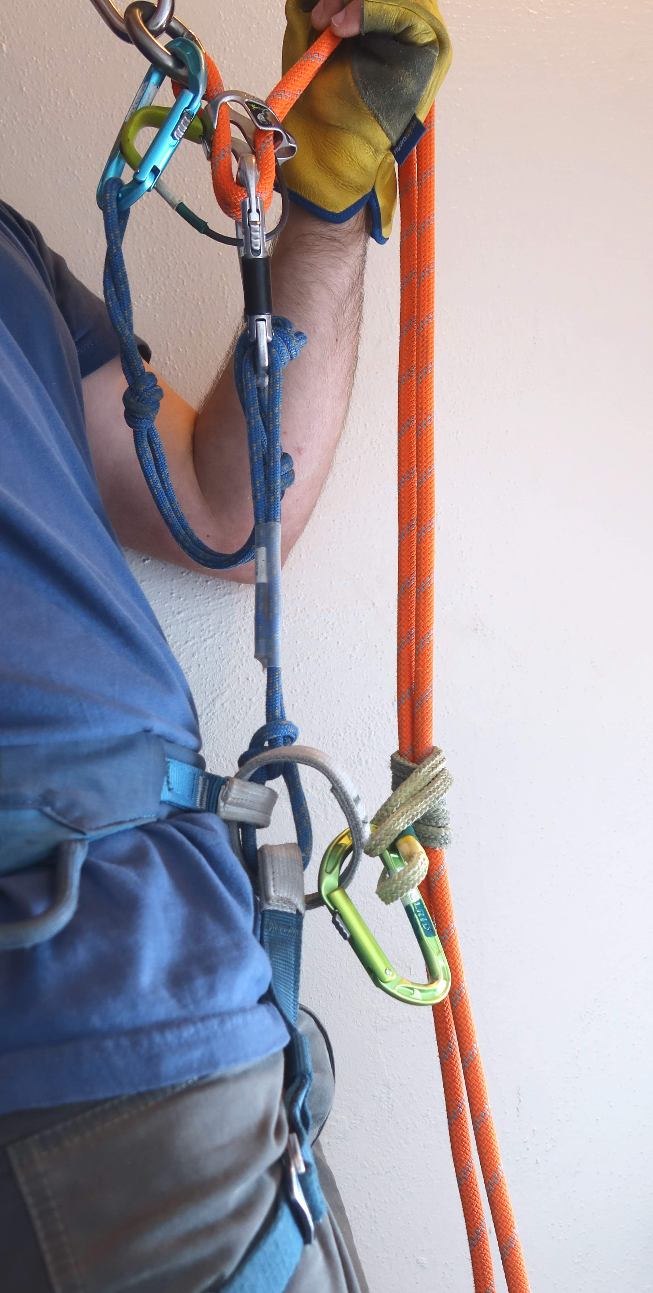
#7. Now actually test: Sit down and put your full body-weight on the rappel setup. Observe that the rappel setup holds you, and that the autoblock engages, so that you know you do indeed have a system that would stop if you were to let go.
#8. Finally, you can begin your rappel. Yell “<<your name>> is On Rappel!“, keep your brake-hand closed around the brake-strands, and unclip your PA from the anchor. A great place to clip the PA’s locker for storage is back to your belay-loop, a nice and convenient place to reach, so that it’s ready to use as soon as the next anchor is in reach.
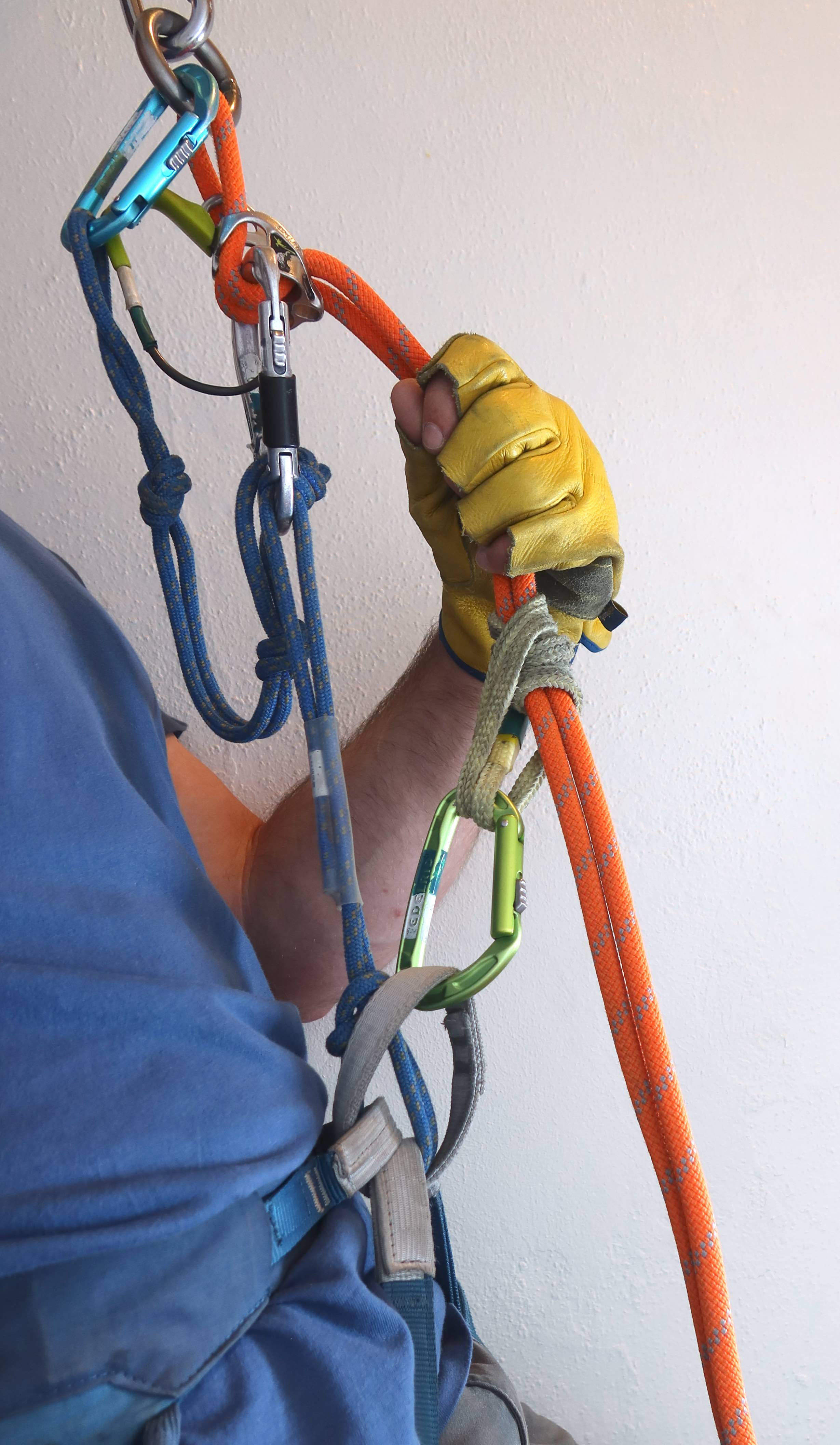
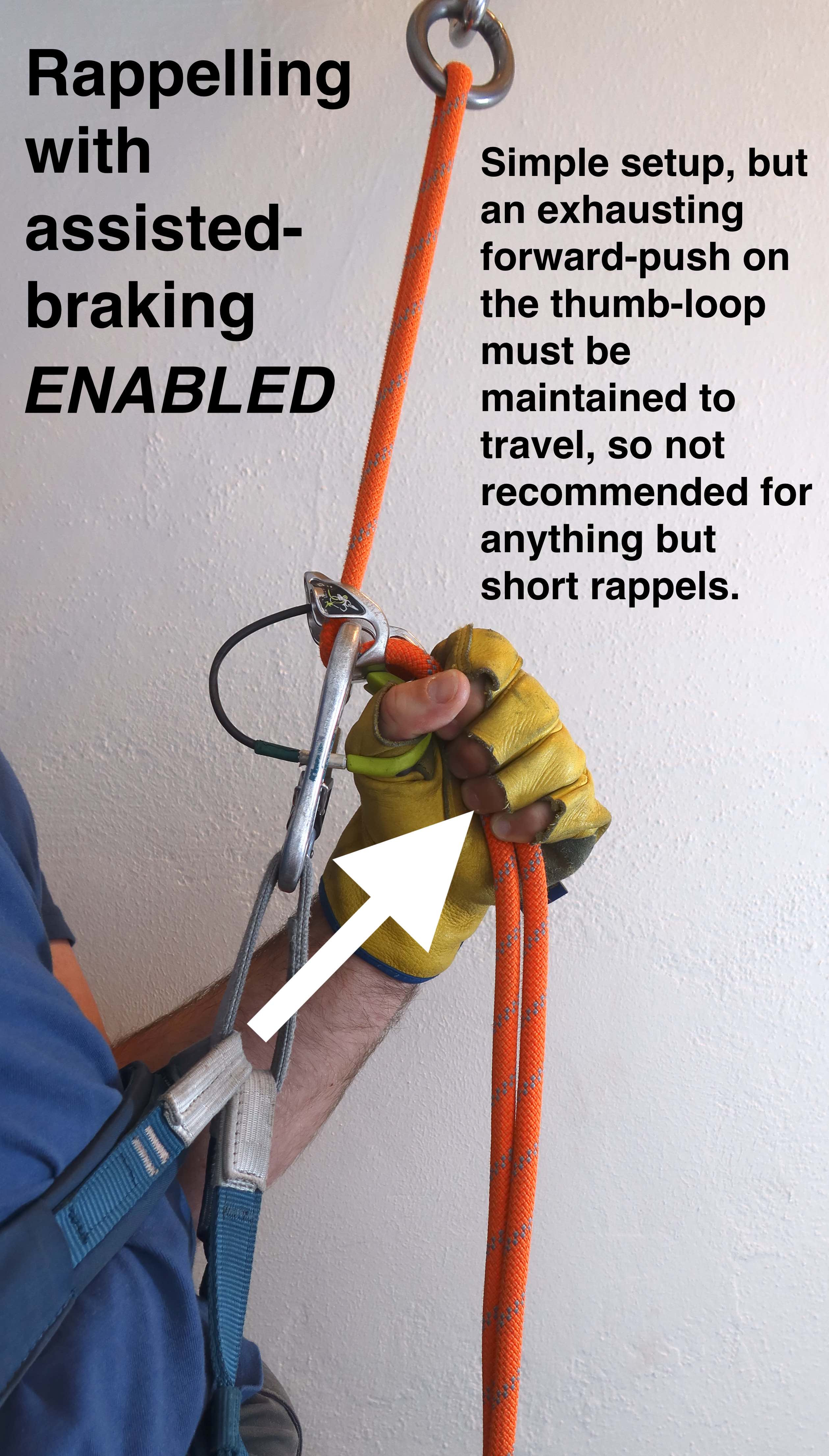
A bit niche: Rappelling with Assisted-Braking Enabled
Above I talked a lot about rappelling with the assisted-braking function disabled, and surely some are wondering: what if you switched things and tried rappelling with the assisted-braking enabled? i.e., instead of the lime-green-thumb-loop being “up and in”, what if it was where you would regularly put it for a normal top-rope-belay or lead-belay? Well, then you would have to use muscle to constantly push forward on the lime-green-thumb-loop to overpower the assisted-braking in order to go anywhere. It does work, but it’s very tiring to maintain that forward push for the length of a rappel, so you’re probably not going to be happy about doing it on anything other than short single-pitch rappels.
No autoblock here: If you are going to rappel with the assisted-braking enabled, then you can skip the use of an autoblock. Remember Rob’s-Rule-of-Rappelling #2? “Always use a system that will stop if the rappeller lets go.” This rappel setup is still compliant with that rule, because it’s the assisted-braking should cause the system to stop if you let go. (But be careful, and don’t put too much trust in the “should” there. It can vary with rope-diameter, which is why: ahem, rule #3: you must always test before you trust!)
No extension: Since there’s no autoblock required, then you can and should also skip the rappel-extension. Instead just set up the rappel directly on your belay loop. This turns out to be necessary for ergonomics, for that constant-forward-push you’ll need to maintain on the thumb-loop in order to move at all. It’s much easier to apply that constant-forward-push to something located close to your waist, than it would be to apply a constant-forward-push to something at the height of your forehead.
The advantage of this setup is that it is very quick to set up and put away, there are a lot fewer extra items involved than the standard rappel setup. I do use this myself, but only occaisionally, in the niche scenario of only one rappel to do, and not that long of a rappel to do, so that it won’t be that tiring on my arm.
About gloves: Personally, I always prefer to rappel with gloves. I generally lightly-encourage others to wear rappel gloves too, but I don’t go so far as saying that they are “mandatory.” If someone I’m responsible for on a trip chooses not to wear rappel gloves, I generally let them make that choice for themselves. However, if you do use this setup, I would give a little extra-encouragement in favor of actually wearing the rappel gloves, I do find that there’s a little more rope-friction against the hands in this setup than there is with extended rappel.
Belaying a Follower (From Above, Plaquette-Mode)
Belaying a follower, belaying from above, belaying in guide-mode, belaying in plaquette-mode are all different ways of saying the exact same thing. There’s plenty of excellent videos out there about the correct setup for doing this with an ATC or Reverso:
But before I show the MegaJul’s version of this setup, we have to talk about a potential problem with ALL of this style of belay device…
First, be aware of a danger that affects ALL guide-mode / plaquette-mode style devices
If skinny ropes are used, and only a single strand of rope passes through the plaquette-mode belay device, it is possible for the strands to squeeze-by eachother within the device’s aperature, as shown here:
☠️ This is a pretty scary problem: with enough of a pull-force downward on the climber’s strand (the direction it would indeed be pulled in a fall) along with a fairly-minor upward-pull on the brake-strand (easy to do, and it doesn’t even have to be an upward pull, just less of a pull than the pull-force on the fallen-climber side can cause this), the result is that the brake-side and climber’s-side of the ropes have passed eachother within the device’s aperature. This means that the built-in braking that any plaquette-mode setup is supposed to provide is no longer there, and without a firm grip on the brake-side, the rope could easily run freely, dropping the climber. ☠️ The above GIF shows this happening with a Black DIamond ATC, and the dark-blue rope is a 7.9mm climbing rope. That rope is rated as a half-rope/twin-rope, and so in theory it shouldn’t be used single-strand like this. However, the key unknown is: we don’t know what rope-diameter this can vs cannot happen with. Some ropes are thick enough that this problem can’t happen, and some ropes are skinny enough that it can happen. I do not know where the line is. And even if we did, it’s probably not a simple universal number, different rope-constructions may do this at different diameters.
So how do we prevent this? One option is to clip that locking carabiner fully around the device, like this:
With the carabiner clipped around the device, then the carabiner is unable to do that 180° flip that happened in the demonstration of the problem, making it much less likely for the two strand to be able to fully pass eachother. So that’s one way of preventing this. Edelrid does recommend this solution in the literature they provide. Black Diamond could be recommending this solution in the literature that comes with an ATC, and Petzl could be recommending this solution in the literature that comes with a Reverso. However, neither of them are recommending this. Why? Well, it is a really annoying solution: it’s kinda hard to clip the carabiner fully-around the device like that. And with the carabiner clipped that way, it’s no longer possible to use the “ratchet trick” to let out just a little bit of rope while under tension. Most of all: I think this “solution” might actually be unnecessary. There is some rope-diameter that’s wide enough that this isn’t a problem, I just don’t know exactly what diameter that is. But I’ve been belaying with single-rated ropes that are somewhere in the middle of the 9.0mm to 10.0mm range for years, and I haven’t had this problem. By far the most common diameter of rope I’ve used is 9.5mm. I’m inclined to think that this isn’t an issue with 9.5mm diameter ropes because (1) it hasn’t been an issue for me personally with ropes of that diameter, and more importantly: (2) if it was an issue with 9.5mm ropes, which is a very common size, other manufacturers would certainly be making changes or at least putting more mitigations in their literature! So, since Black Diamond is okay with me belaying with a single-rope without clipping the carabiner around the device, and Petzl is okay with me belaying without clipping the carabiner around the device, and Edelrid’s MegaJul works on the exact same physics as those two devices when setup for plaquette mode: I’ve decided to go back to simply clipping the locking carabiner behind the MegaJul, rather than around it.
The MegaJul-Specific Setup for Belaying From Above
#1. Hang the device from the anchor like this:
#2. Push the rope in up from the bottom. That “up from the bottom” part is the main weirdness about the MegaJul here if you’re used to using an ATC or Reverso in plaquette-mode.
#3. Now to clip that last locking carabiner…
This is when we need to think about that danger that affects any plaquette-style belay device described above, that danger of carabiner-flipping and rope-strands trading places. Do we clip the locking carabiner in the back so that it hangs freely? Or do we clip the locking carabiner fully around the MegaJul? I talked through my thought process on this above, with the ATC example, and personally, as long as my rope is about 9.5mm in diameter or thicker, I simply clip the locking carabiner in the back so that it hangs freely, like this:
And here’s the whole process:
#3-Alternate:
Alternatively, if you did want to clip the carabiner fully around the belay device, you can do so. (Note: if your rope is skinny enough to need this solution, then you would also need to do this solution if you were using a BD ATC or Petzl Reverso instead.) Folding a loop of rope over can make the clipping much easier, like this:
Advanced Skills
Advanced Skill: Lowering a Follower
Advanced Skill: Raising a Follower
Advanced Skill: Switching mid-rappel to rope-acension
The route is inherently time-consuming, even with strategies employed to “go fast”. To climb the West Ridge, the two most appealing strategies are (1) do it in-a-day, with no backcountry camping, or (2) get backcountry camping permits for the ‘Boston Basin Cross Country Zone’ (organized under “High Use Cross Country Zones”) and spend at least one night at the Boston Basin High Camp (at 6200′, around 48.5012, -121.0638). Whether you camp or not, going for the summit is going to be quite a long day. In-a-day, you can expect a 17-hour car-to-car day if things go well, and it’s certainly possible for the day to be considerably longer if anything goes less than perfectly. Even with camping: a 12-hour day camp-to-camp is fairly common. The approach from car to camp can be only 3 hours if you bang it out. Getting out from camp-to-car can be only 2 hours. (But add an hour to break camp, so even with high-camp strategy, camp-to-summit-to-cars becomes a 15 hour day in best case scenario; still a very long day.) In any case, parties should be prepared for the possibility of an emergency-bivy somewhere unexpected, as the chances doing one are relatively higher on this route than most. I recommend each person carry a light mylar emergency bivy bag, a bit of extra food, maybe some caffeine, and extra headlamp batteries (or perhaps a whole second headlamp) in their summit-packs, just in case. The biggest hazard on this route is other-parties, both in terms of potential rockfall concerns in the Cat Scratch Gullies, and also just the time-cost of traffic delays. One of the best ways to make this route relatively-safer is to climb on a weekday, instead of a weekend. It’s also significantly easier to get camping permits for a mid-week trip. Even though camping doesn’t shave that much time off of summit-day compared to doing the trip entirely in-a-day, camping with an alpine-start gives you much better odds of actually being first on-route than starting from the cars with an alpine-start.
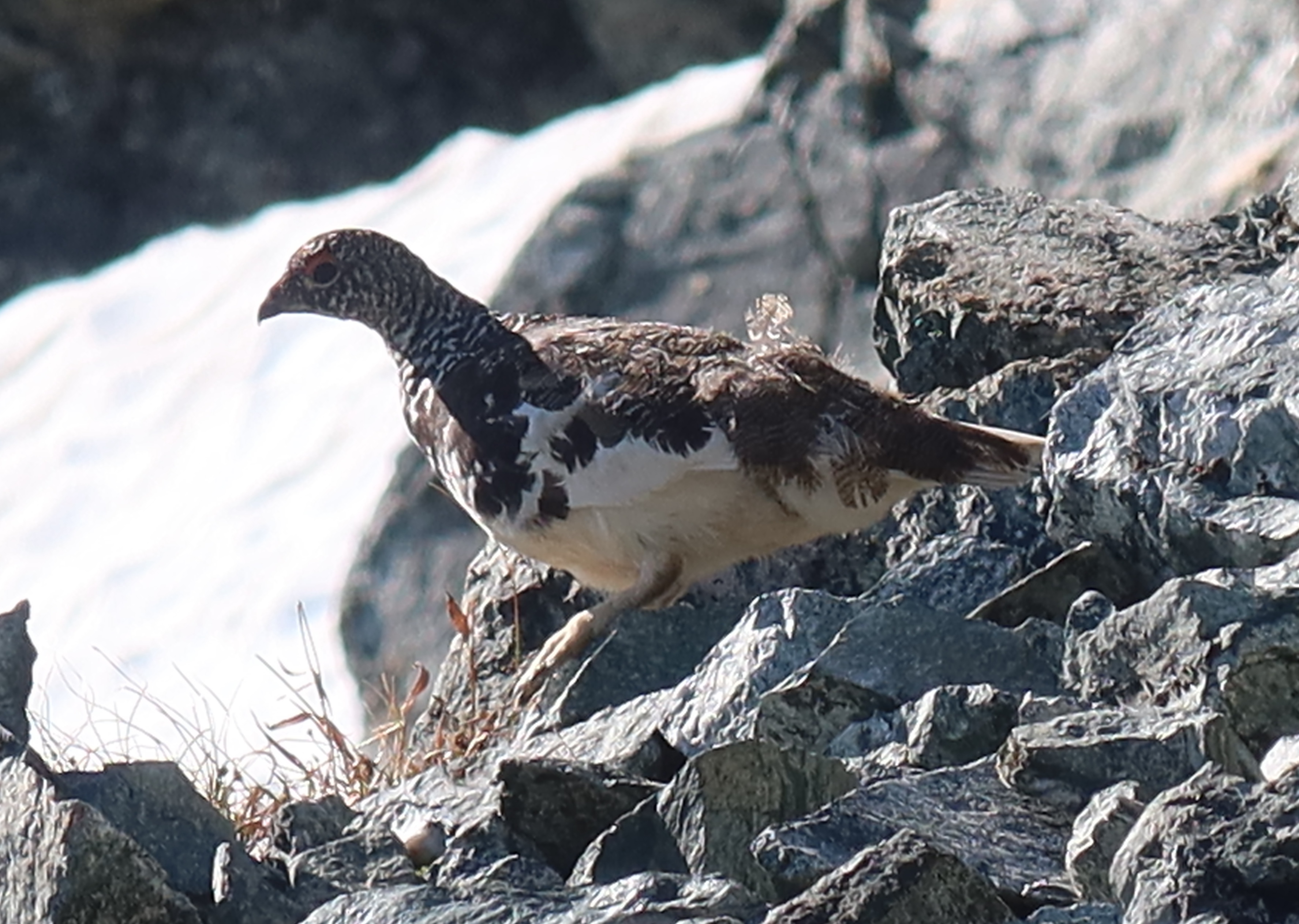
We got to see a ptarmigan on the Ptarmigan Traverse! That’s gotta be some kind of good omen. We saw this guy along the scramble up the the summit of Le Conte.
The Ptarmigan Traverse is an absolutely classic and must-do experience at least once for anyone who’s into mountaineering in Washington state. Some high-level details:
Technical skillset: In its simplest version, as just a through-traverse (e.g., not yet considering side trips to summit nearby peaks), it can be done with only a “Mountaineers Basic” skill-set: the technical challenges are basic glacier travel and scrambling, and the trip is otherwise essentially backpacking-for-mountaineers.
Time commitment: While this route has been trail-run in insanely fast times, if this is your first time on it, I’d recommend allocating something more in the ballpark of a 6 or 7-day schedule.
A car-shuttle is required, which (from Seattle) means nearly 6 hours of driving prior to the boots-on trailhead at the beginning, and nearly 6 hours of driving after the boots-off trailhead at the end. Two cars are required, and each must display a Northwest Forest Pass (or an America the Beautiful Pass).
Permits: Somewhat astoundingly, this route doesn’t require any camping permits (yet… I imagine some day in the future it will.) What an incredible gift from nature this place is in the first place, and what a privilege it is that we are currently able to recreate there without the hassle of a permit system being needed yet. Popularity is only increasing, and it is crucially important that we each do our part to care for and preserve the land here by doing everything we can to minimize the way our presence impacts it: avoid killing the struggling alpine plants by–as much as possible–avoiding going off-trail and stepping on them, or setting up tents on top of plants, or peeing on plants (which will make a mountain goat eventually dig at that spot, shredding a square foot or so.) Store food appropriately (large Ursacks are ideal) to avoid habituating wildlife, which could lead to area-closures, and you don’t want to be “that guy” that ruins it for everyone else. And practice good backcountry bathroom etiquette (more on that below, but in short: at least pack out your used toilet paper!!) Be thoughtful and continuous towards the land, keep the area just as beautiful for the people who will come after you; and don’t do anything that would hasten or become a reason why a permit system would need to be established.
The prime time of year to aim for is likely early to mid-July (for the best chances of stable sunny weather, but also crevasses not having opened much yet.) Consider avoiding a schedule that incorporates the July 4th holiday, though, as it is likely that a lot of other people will have the same idea, and many of the camps along the route are limited in space.
An alternative to the Ptarmigan Traverse: For a similar trip in many ways, another option is the Bacon-Hagan-Blum Traverse, detailed in this video: https://www.youtube.com/watch?v=06M05mRV5pc&ab_channel=TheMountaineers It’s not quite as classic as Ptarmigan, but it is also an outstanding trip of its own, and would be significantly less crowded, even if scheduled over a national holiday.
On Saturday, June 14th, 2025, Kelly Ryan and I climbed a rock buttress in the Washington Pass area that had no previously-documented ascents. It has 1000′ of mostly moderate and enjoyable granite climbing, with trees available for almost every belay station. The route is solidly Grade III in size. We swung leads for eight long pitches, where I led the odds and Kelly led the evens. We estimate that maybe one pitch was 5.9, and a number of others were 5.7 / 5.8, but we look forward to second-opinions, as there were factors that could have led us to over-estimating difficulties at the time. The buttress overall has a fairly consistent slope-angle of just over 60°. There is a walk-off from the top, which returns to the route’s base. The route is minorly committing, in that completing it and walking off would be the preferred way off; though if a mid-route retreat were really necessary, many trees are available that a party could leave slings on, and a series of many <30-meter rappels would return you to the beginning.
The Mountaineers is a big part of my life, it’s big a community which I very much love and appreciate! I’ve long been plugged into the Seattle branch and the climbing programs there.
If you are new to The Mountaineers, here are some links to help you orient:
The overall list of visible upcoming scrambling & climbing courses: https://www.mountaineers.org/courses/courses-clinics-seminars#c9=&b_start=0&c4=Climbing&c4=Scrambling (Note: Many courses repeat on a yearly cycle, and have an application period and sign-up during the late-fall or early-winter months, e.g. Oct, Nov, Dec., so to get in that’s when you need to be looking & applying. The actual course workshops/lectures/field-trips/etc. typically happen during the late-winter & spring months, mostly wrapping up by June. Then, during the summer-ish months, June through early October, anyone who is an approved Scramble Leader or Climb Leader can post Mountaineers Scrambles & Climbs as official-club-activities in the mountains, and students who were in courses need to sign up for and complete a certain number of those in order to fully graduate from their course.)
If you’d like to sign up for a course but aren’t sure which one, this unofficial diagram may help you navigate the rather-complicated structure of available courses.
If you have climbing experience outside of the Mountaineers and believe you qualify for ‘Equivalency’ for some course, read this page about Equivalency.
Unfortunately, the most significant and most long-running problem faced there is that it is so hard to get on climbs, and has been for a long time. At least the official-club-climbs posted on the website. The problem is a huge asymmetry between the small number of official Climb Leaders who are posting trips, and the enormous number of students & graduates & other people trying to get on those trips. And I really do wish there were plenty of trips for everyone!! I love seeing people get outside and be active!! But a limited supply arises from issues with both the process of becoming an approved Climb Leader, (At what point is the level of friction in that process actually too much friction? Is the number of newly-approved Leaders unintentionally throttled more than necessary?) And also issues with the retention of active Climb Leaders: it’s entirely volunteer, and it’s kind of a rough job, it is so much easier to be a participant than it is to wear the responsibility of leadership (if the choice were there, pretty much everyone would rather sign up for a trip than lead one themselves), and enough people make it harder on leaders–whether they realize they are doing so or not–that leaders feel a lot of discouragement from leading trips. Fortunately, many leaders so strongly want to give that they overcome frequent-minor-discouragements for a very long time and still post a lot of trips, but retention isn’t going to last forever that way.
And I say to the the leaders who are active and posting trips: THANK YOU!!! No matter what trip you post, whatever personal-preference you have about how you post it or what you require for it, and even if you are only posting just one trip a year, still THANK YOU!!! You are giving a gift, and it is appreciated. Every single trip posted is one more trip posted, every single trip posted is an incremental addition. Every little bit helps, and the best path forward here is to get more trips posted!! Let’s create more leaders, and also make it more enjoyable for leaders to lead!!!
Okay, so what should you, as a student, be doing to get on official Mountaineers club climbs?
If you are into mountaineering, Sloan Peak is a must-do classic summit. Its distinctive shark-fin shape and rather central location in the Cascade range make it a familiar appearance on the horizon from many other summits. That also means that conversely, when you do summit Sloan, you will be surrounded by a plethora of sightlines to many other familiar mountains in the North Cascades and Alpine Lakes regions, indulging both nostalgia for climbs-past and fueling stoke for climbs-future. And even aside from the views, the route itself is a fun romp on varied terrain, a sampling-platter of many alpine elements, but no part is so spicy that it’s overly stressful, and no part so big that it feels like volcano-slog. Overall, I find it to be delightful day out compared to many other larger or more-stressful alpine climbs. Heck, it could even be a good “first glacier climb” for someone to get experience with their systems on the relatively-short glacier crossing, as long as they’ve got the fitness and scramble-experience to be otherwise ready for the day.
Overview
The key difficulties are basic glacier travel, and a fair amount of 3rd class scrambling.
When to go: July & August are the safest bets for finding the route in good condition. Above 7200′, the route makes use of lovely trails on high heather ledges, but with a ~500′ drop over a precipice at the edge of the ledge. Those ledges must be snow-free to be safely passable, so snowcover there will likely turn-around attempts on the summit before late-June. On the other side of summer, you want to go before the glacier crossing gets too broken up. I’m not entirely sure at what point in summer the glacier typically becomes impassable, but my guess is sometime in September. I imagine summits could still be made during September, but the difficulty and technicality of the glacier crossing will go up.
Summit at 7835′.
Note that there are two different trailheads / approaches from which Sloan Peak can be accessed. (1) from the north, the “Sloan Peak Trailhead” (a.k.a. “Cougar Creek approach”) at 1919′ elevation, is a pull-off along road FS 49, where the road is better, but the North Fork Sauk River must be crossed, which is a pain at best, or a complete blocker at times of high-water. Or, (2) from the west, the “Bedal Creek Trailhead” at 2790′, which requires driving a pretty awful side-road (FS 4096) to access, but once the drive is done it’s all better from there, starting higher and with no creek to cross. I’ll focus on the approach from the Bedal Creek Trailhead.
Par-for-the-course on time is about 13 hours car-to-car. Or notably less if your party is particularly experienced & efficient.
In my opinion, the best way to do the route is in-a-day, with a car-bivy the night before, so you can start hiking at perhaps 4:00am. (Though if you really wanted to camp out there, you could do so, there’s space for 4 to 6 tents total (consider other parties) at 48.05673, -121.34298, at 5380′, near a pond that’s a bit stagnant.)
The FS 4096 road is quite bad, you definitely need a 4WD or AWD vehicle to get up it, and a decent bit of ground-clearance would be a good idea too.
On July 26-28th, I had the opportunity to climb the Complete North Ridge of Stuart, as a 3-day trip. I’m so stoked and grateful that this opportunity came up, and that we were successful, I finally got to climb this route!! I have long dreamed of climbing this ultra-classic, since my first trad lead more than 12 years ago. I had held off on going for it for a long time, primarily out of concern about the climbing-difficulty of the crux pitches. I wanted to be extra-sure of my ability to on-sight 5.9 trad before making an attempt. I felt ready a few years ago, and had made an attempt, but opted to turn around before roping-up because the weather ended up being significantly cloudier & windier than what the forecast had predicted. This time though, everything went right!
There’s plenty of other information out there on the North Ridge, some I’m not necessarily going to write a complete guide to the route here. Even if I wanted to, a complete guide that shows where to go on all the pitches wouldn’t be possible or practical, there’s just so much ground to cover, it’s more important that you’re able to route-find on your own. This post is just going to be some notes from my one successful experience on the North Ridge of Stuart, partial beta that may or may not be a useful ingredient in the formulation of your own plan 🙂


