The Plan
 Three of us (myself, Abby Hunt, and Ben Fox) would make a 7 day trip traversing the Northern Picket range of the North Cascades with attempts to summit Whatcom, Challenger, Fury via its North Buttress, and Luna. That nicely ordered the technical difficulty of the climbs as easy, medium, then hard, and then Luna as an easy dessert on the end. This is very similar to the first half of one of Steph Abegg’s trips, and we pulled a ton of useful beta from her trip report. We aimed to go light & fast, but anyone who’s hiked with me knows I don’t cut corners on safety-related gear, and on a trip like this all gear is safety-related gear. (Yes, I know speed is safety too, but I’m often not the slowest member of the group. Except for this time.)
Gear Details
Our main concern was Fury’s North Buttress, but we also had some glaciers to cross. We brought one skinny 60m rope, BD cams #0.3 through #3 each with a biner, a set of nuts, 3 pickets, 10 slings with a biner on each (more doubles than singles,) a few spare biners for the nut placements, and two cordelettes. We each brought our own harness, belay device, texas prusiks, and about 4 lockers. We each brought two mountaineering axes to deal with the steep snow pitches on Fury (I had a 70cm BD Raven and a 50cm CAMP Nanotech, a combination that proved incredibly versatile and I’d happily use again.) We all had steel crampons, which I was thankful for since there were a lot of places we crossed rock, and as always my faithful Asolo 520’s successfully pretended to be mountaineering boots. I packed rock shoes, but they ended up only being dead-weight in my pack. We shared an MSR Whisperlight and started with a liter of fuel. A steripen was our go-to water treatment, though we carried a little iodine as a backup. A Big Agnes Fly Creek sheltered Ben & I, while Abby brought a bivy. If the weather got nasty, the plan was to scoot the head of her bivy under the vestibule of our tent. Ben & I both brought substantial first aid kits (he’s a W-EMT and I’m a WFR,) and he even had a satellite phone, which made me feel a lot better. The real kicker in terms of pack weight for me was the amount of food I brought. A previous off-trail experience had overly convinced me of the need to bring extra food, in case we ended up having to go back the way we came near the end of the traverse, so I had packed a whopping 18 lbs of food providing a total of 29,300 calories to divide over the 7 days. That put my initial fully-loaded pack weight (including 2 liters of water) at 59.5 lbs. That was definitely too much, but I was unwilling to cut any corners before starting out.
Day 1
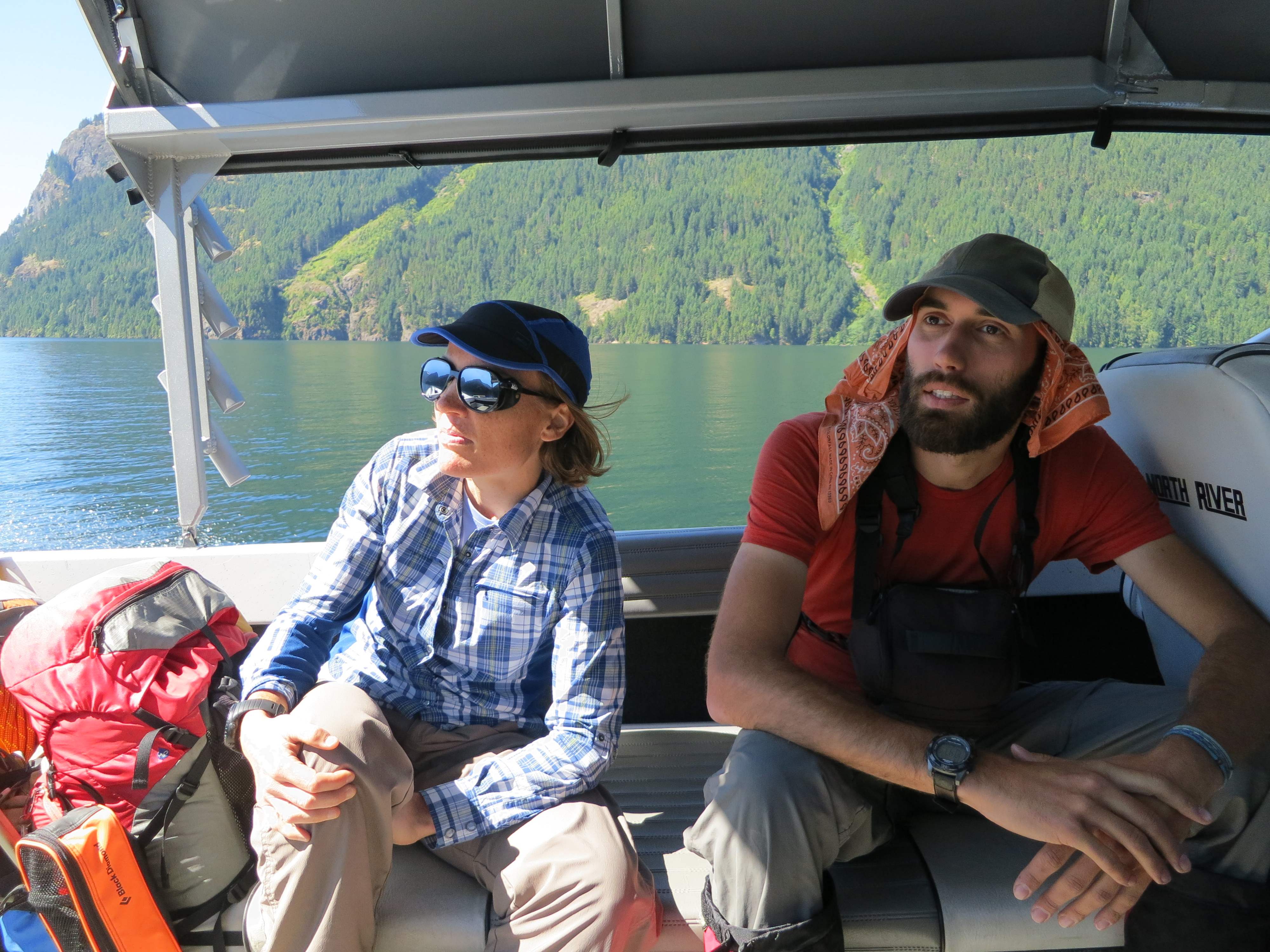
 We had a reservation at 8:30am for the Ross Lake water taxi to take us to the Little Beaver trailhead. (Friday, July 26th.) To make it there in time, we were meeting in Seattle at 5:00am to combine into one car. After the final touch to my packing (printing & ziplocking copies of Fred Beckey’s pages and Steph Abegg’s website,) I set an early alarm and went to bed. I woke up restlessly a few times during the dark & quiet night. One of those times the digits on the clock read five-three-two. Shit. I scrambled, called Abby, grabbed a poptart, looked in puzzlement at my correctly-set-yet-silent alarm, and hit the road, arriving at the meet-up by 5:50am. As we hastily piled our gear and ourselves into Ben’s Toyota, I asked Abby: “We have three pickets, right?” “Right.” So I left the spare picket I had brought just-in-case in the back of my parked car, and we drove off. Abby tried to make up time on I-5. Unfortunately, a Washington State Trooper disagreed with this strategy, and we earned ourselves a ticket. Bummer. Eventually we called the Ross Lake Resort to see about changing our water taxi reservation time. They said the next time they could do was 10am.
 So much for our early start, but that also wasn’t too bad either considering we were totally at their mercy to get to Little Beaver. I was feeling super guilty, but also relieved that I hadn’t cost us a full day. At the Ross Lake parking lot, Abby divvied out group gear: Ben took the rope, she took the rack, and I took the stove & fuel. It was at this point we realized how our earlier communication about the number of pickets was ambiguous: we were all on the same page about bringing three total, though I thought Abby was bringing all three and handing them out, whereas she thought I had brought mine so she only packed two, understandably thinking that made three total when she answered my earlier question. Well, two pickets it’ll be then. Fortunately, each of us carrying a second axe meant we’d have extra improvised snow anchors anyway. The trail from the parking lot to the edge of the lake was short & straight forward. It’s a little less than a mile and drops about 500′ of elevation down to the lake. It’s well-signed, and has outhouses at both top and bottom. The phone to call the resort is easy to find. After we let them know we where there, it was a long wait on the dock before the water taxi showed up. In the mean time, tons of resort-goers came by and took the shorter ferry ride to that floating hotel.
  We were amazed at the amount of luxury gear that travelled with them: giant coolers and Costco boxes of drinks. Sure, there’s a time and place for both kinds of trips, but what we were doing was so different. Finally our water taxi arrived, and we ended up sharing it with a couple headed to Lodgepole Camp with their two dogs. That was great, because sharing the water taxi nearly cut the cost in half for us. Finally, the boat dropped us off at the Little Beaver dock at 11am. We confirmed our reservation with the boat driver to be picked up at the other end: 9am on Thursday August 1st at Big Beaver, and then he drove off and we were on our own. We had 14 miles to cover before we reached Twin Rocks camp, our goal for the first day. I was surprised to find the trail switchbacking up hill right away, I had envisioned the gentle grade of a river-walk the whole way. Fortunately, it was still really tame for an uphill and leveled off after a little while, and we maintained an amazingly brisk pace of slightly over 3 miles per hour while moving, even with our heavy packs. We only took packs-off breaks at the major landmarks of the trail: the other official camps, and at the intersection with Big Beaver. Thanks to all that speed and efficiency, we rolled into Twin Rocks at 5:10pm, amazingly putting us back on Schedule after all of the morning snafus.
 Along the way, the trail was very well maintained, although a bit overgrown. Every stream either had a crossing log or was easily rock-hopped. We indulged on number of trailside thimble berries & salmon berries that could be grabbed without breaking stride. There were some really impressive old-growth cedars along the way, and even a glimpse of Mt Prophet to the south. At camp we were treated to our last human contact for a few days. We met Guillermo and his son Daniel, who camped near-by, doing a father/son backpacking trip. They had spent the day hiking up to Whatcom Pass for the views and back down to here as their base camp. After chatting with them for a bit, we hung our bear bag and called it a night.
Day 2
 We got up early, packed up surprisingly quickly, and were on the trail by 6am. The trail is a little rougher and more overgrown than the day before, but fortunately the rumors of devils club never materialize for us. It isn’t long before we start getting glimpses of Whatcom Peak, and part of the Challenger Glacier. Half a dozen waterfalls streak down the sides of our valley.
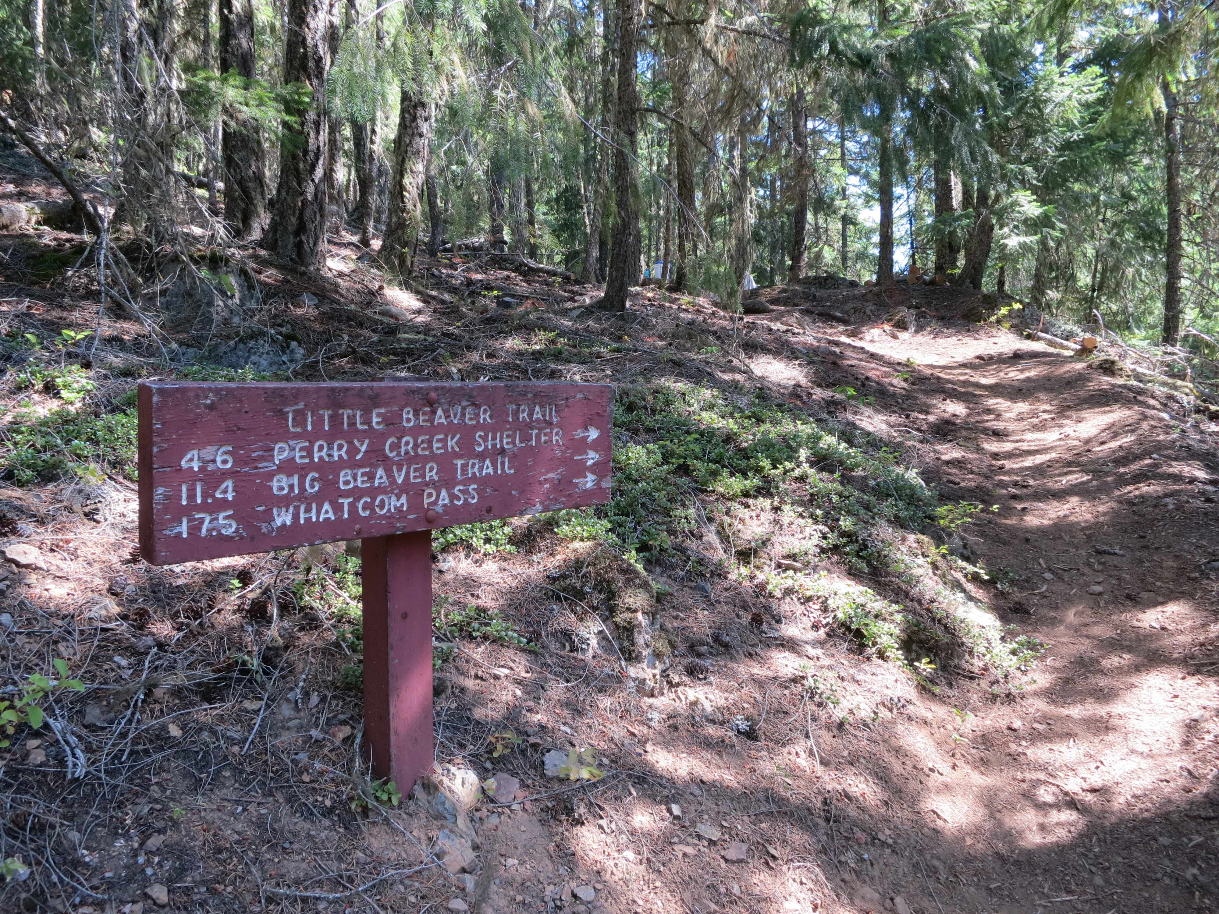
  Twin Rocks is at 2700′ elevation, and Whatcom Pass is at 5200′, so the switchbacks begin soon, and I fall behind my two companions in terms of speed. One section of switchbacks is held together with wooden retaining walls, which is more trail maintenance than I expected to see this far in. Shortly afterward, forest gives way to alpine meadow, and things level out. This was a good time for us to top up our water supply before going higher. We kept left at all trail intersections up in the pass area, including a left onto a trail that looks like it’ll take you around Point 6230 without having to go up and over, but instead peters out to nothing in the meadow.
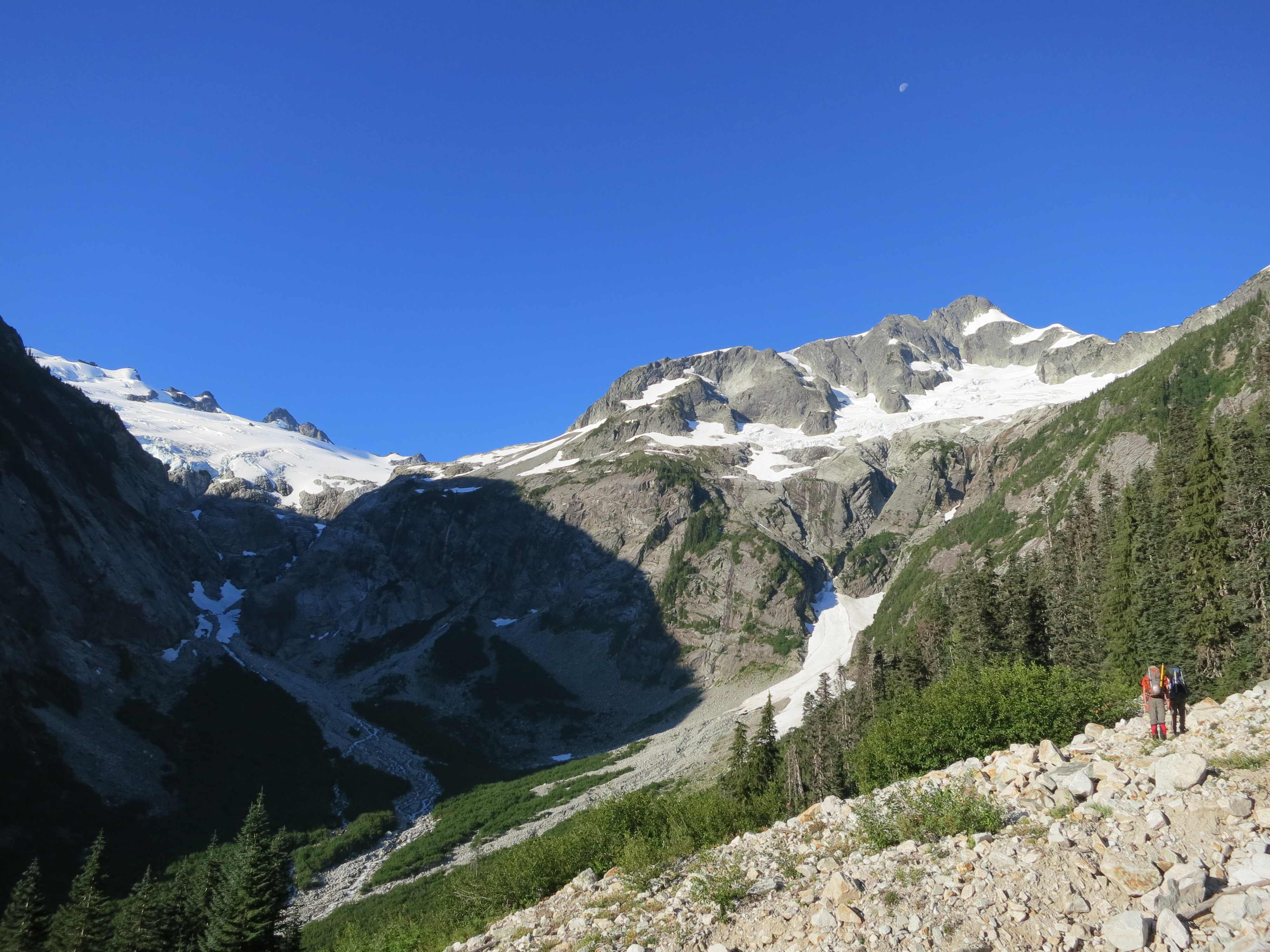
  Abby had wanted to go up and over that rise off trail before then, and I should have listened to her, since curving around the left side of this rise put us in a steep treed slope that was slow going and more difficult to traverse than just gaining a few hundred more feet of elevation would have been. Eventually a clearing with a talus field let us gain the ridge after all, and we followed the ridgeline as it started to climb Whatcom itself.
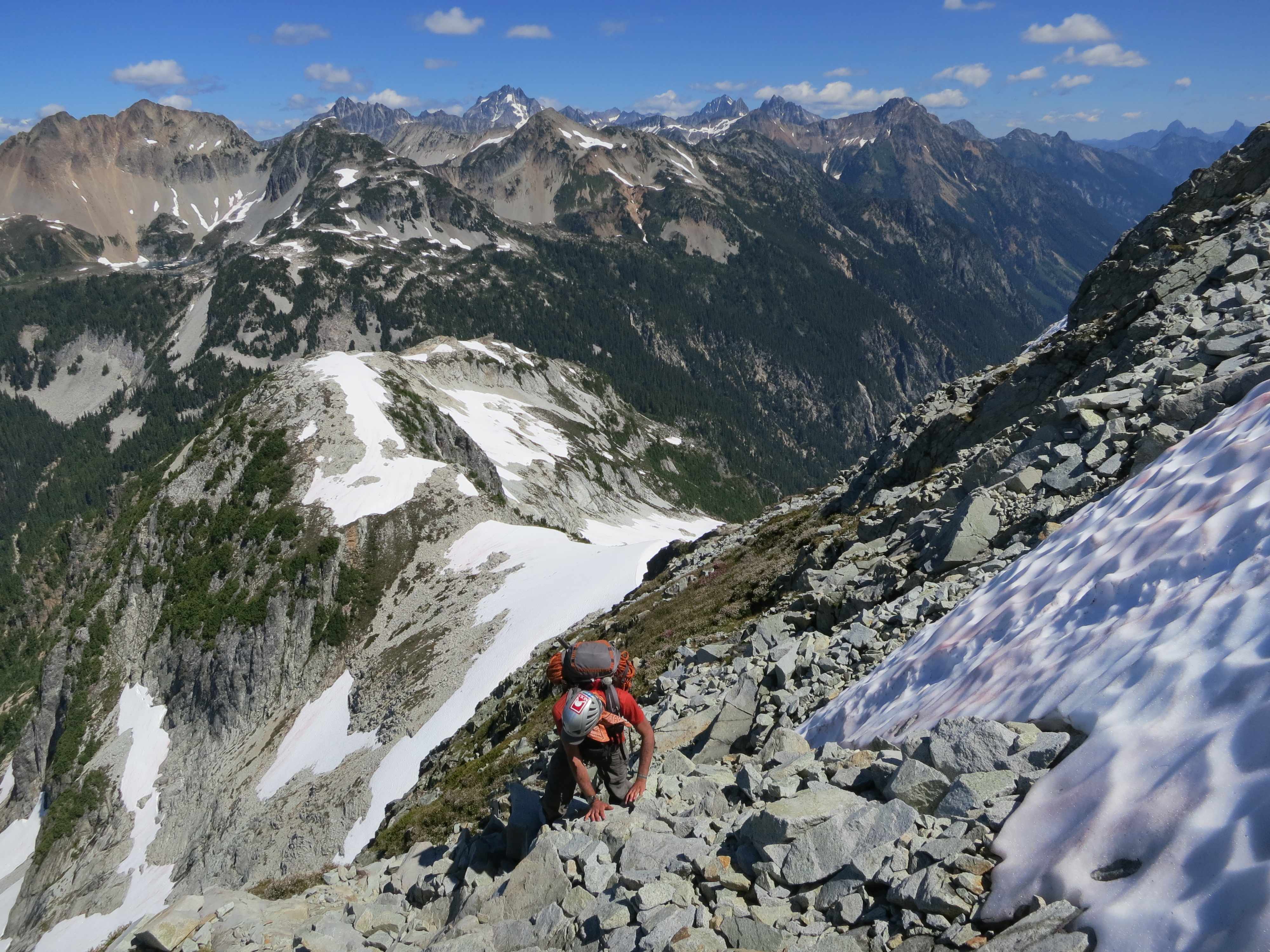
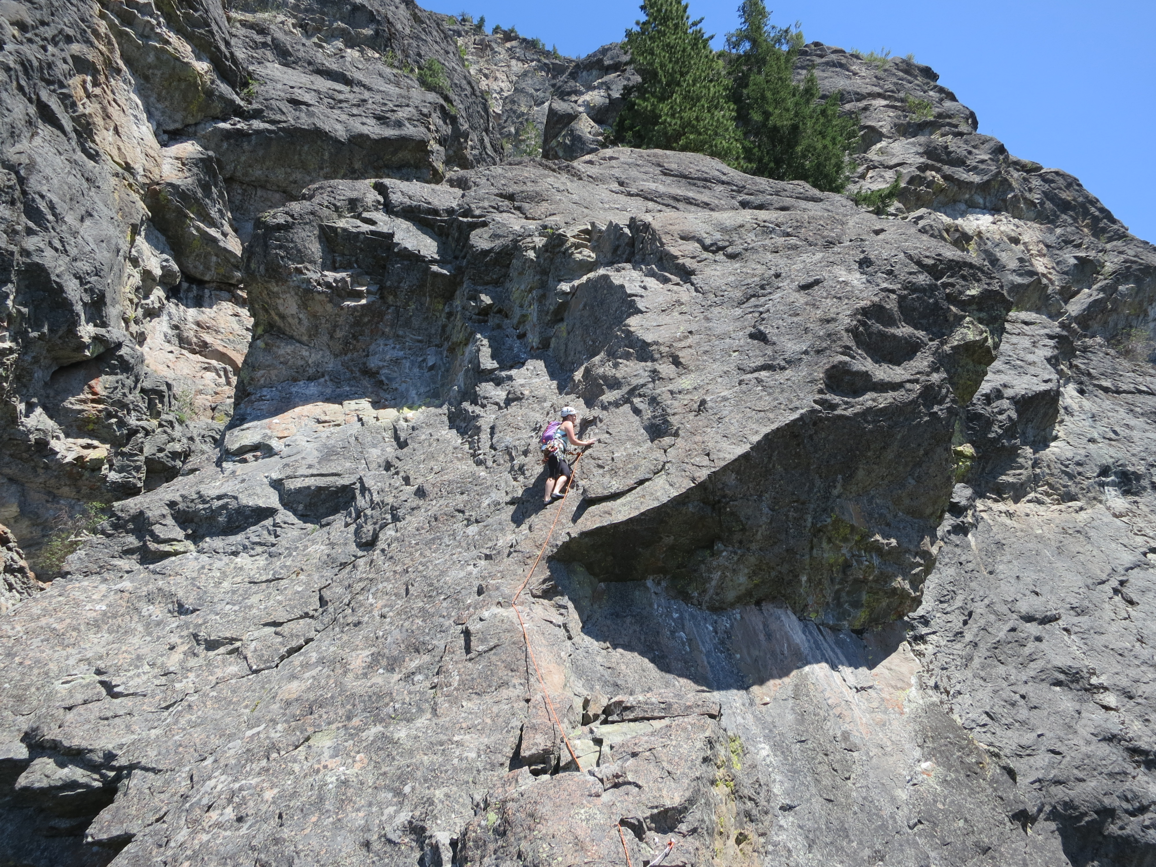
  We stayed right of the snowfields clinging to that north ridge of Whatcom, and soon we naturally ended up on the exposed 3rd class scramble up the northwest face of Whatcom. It was about noon when we started the 3rd class scramble, and 2:30pm by the time we got off it by reaching the summit via skinny ridge that shoots out its western side. Meanwhile, during the scramble, many of the rocks were loose, the exposure was a little crazy, so it was mainly an art of finding the most solid thing you could trust for a hand or foot hold.
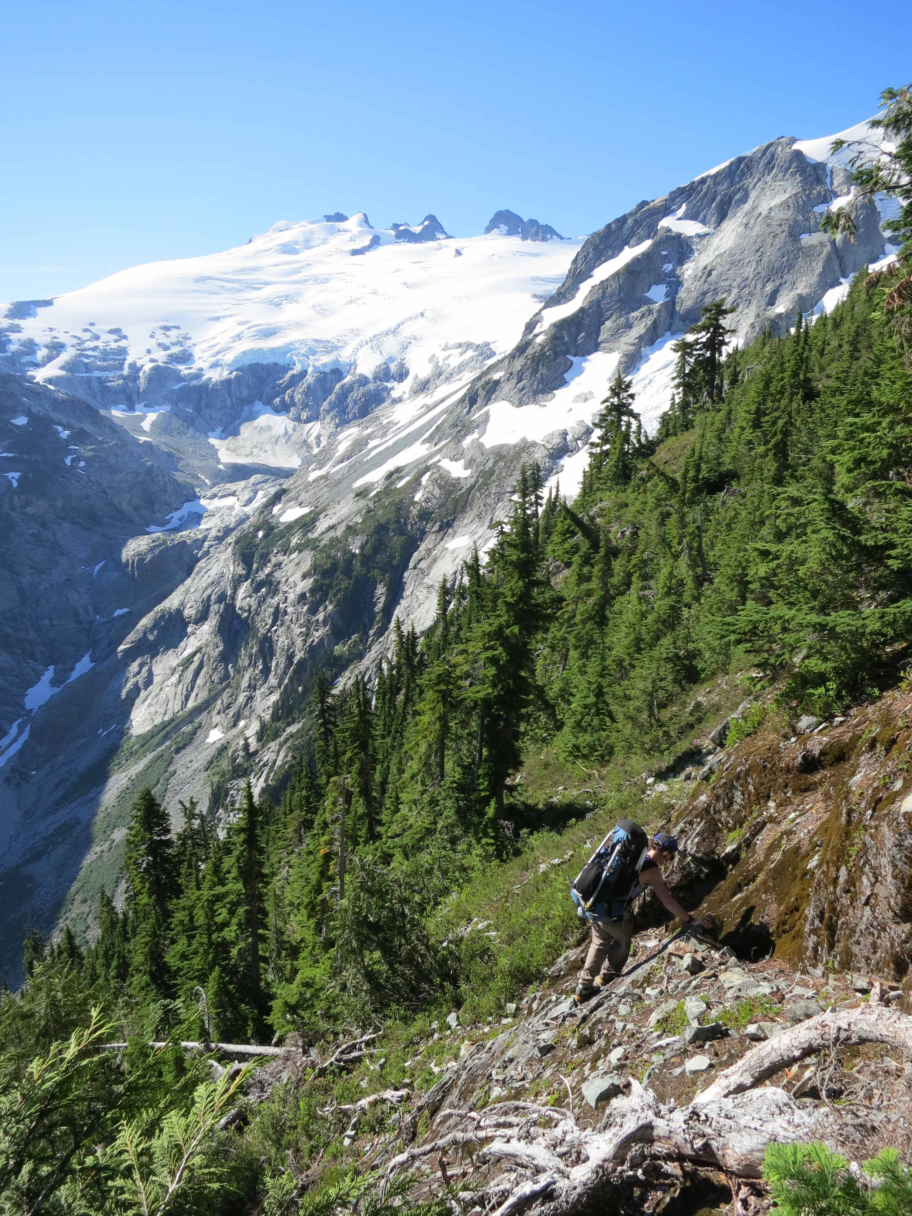
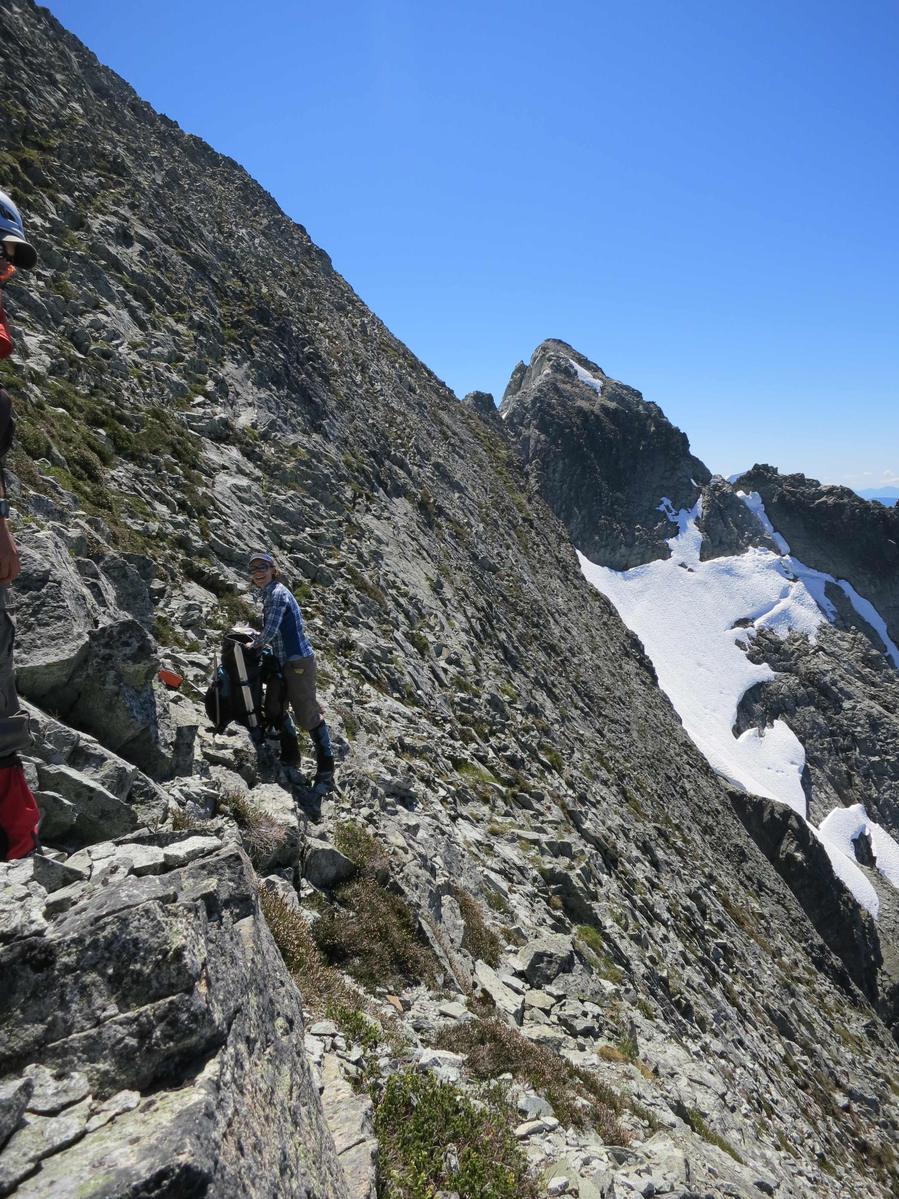
  Both going up and from the summit, the views of Baker and Shuksan were phenomenal. We signed the summit register, and we were stoked to see that Steph Abegg had signed it only a few lines above us! (Her trip was last summer, so that’s a testament to how few people actually do this.) I’ve never met her, but her website and trip reports have been a crucial source of information for us. From the summit, Perfect Pass is visible as the first major low spot on the ridgeline continuing on towards Challenger. Whatcom’s summit is also a fantastic vantage point to scope our Challenger, it’s glacier, and the little rock wall you have to descent to get on the glacier from Perfect Pass.
  We lingered on the summit until 3:10, then scrambled our way back down that skinny ridge onto the nice plunge-stepping snow down to Perfect Pass. After stops to fill up water, and time to scope the area for the best camping spot, we eventually laid down our load for the day by 4:30pm.
Unfortunately, I never did finish this trip report 😦 Email me if you’d like the rest of the story, maybe it’ll inspire me to write more.


 Fast forwards around 10 years. I planned a trip to finally go to Roaring Spring for August 3 with my friend Kyle from way back in middle school. It was a reasonable drive from Salem, with only a mile or two of gravel road. We pulled off the road and scrambled down into a dry creekbed. After descending the creekbed, we traversed and bushwhacked through thick rhododendron bushes until we heard a faint roaring noise, which got louder and louder until we got to the edge of a ridge, and we saw…